IMAGES TAKEN NEAR TO
The Fens, LEISTON, IP16 4QR
Introduction
This page details the photographs taken nearby to The Fens, IP16 4QR by members of the Geograph project.
The Geograph project started in 2005 with the aim of publishing, organising and preserving representative images for every square kilometre of Great Britain, Ireland and the Isle of Man.

There are currently over 7.5m images from over14,400 individuals and you can help contribute to the project by visiting https://www.geograph.org.uk
Image Map
Images are licensed for reuse under creativecommons.org/licenses/by-sa/2.0
Notes
- Clicking on the map will re-center to the selected point.
- The higher the marker number, the further away the image location is from the centre of the postcode.
Image Listing (15 Images Found)
Images are licensed for reuse under creativecommons.org/licenses/by-sa/2.0
Image
Details
Distance
1
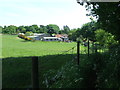
Birds Farm
Birds farm near to Aldringham, Suffolk.
Image: © Keith Evans
Taken: 27 May 2015
0.14 miles
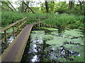
2
Raised Walkway
Raised walkway near to Thorpeness, Suffolk.
Image: © Keith Evans
Taken: 27 May 2015
0.14 miles
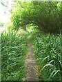
3
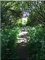
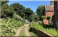
Footpath leading to Bird's Farm, Aldringham
Image: © Roger Miller
Taken: 4 Mar 2007
0.14 miles
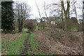
6
Footpath
The footpath across this marshy area is made of old railway sleepers laid end to end.
Image: © Roger Miller
Taken: 25 Jun 2006
0.15 miles
7
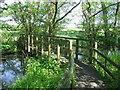
Footbridge
Footbridge near to Thorpeness, Suffolk.
Image: © Keith Evans
Taken: 27 May 2015
0.19 miles
8
Across Open Field
Footpath across an open field near to Thorpeness, Suffolk.
Image: © Keith Evans
Taken: 16 Apr 2015
0.20 miles
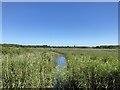
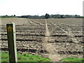
10
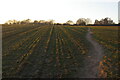
Footpath over sown field, south of Aldringham Common
Late afternoon light from a low sun shines across the ridges and furrows in the field.
Image: © Christopher Hilton
Taken: 28 Feb 2021
0.21 miles