IMAGES TAKEN NEAR TO
Stony Lane, LEISTON, IP16 4NB
Introduction
This page details the photographs taken nearby to Stony Lane, IP16 4NB by members of the Geograph project.
The Geograph project started in 2005 with the aim of publishing, organising and preserving representative images for every square kilometre of Great Britain, Ireland and the Isle of Man.

There are currently over 7.5m images from over14,400 individuals and you can help contribute to the project by visiting https://www.geograph.org.uk
Image Map
Images are licensed for reuse under creativecommons.org/licenses/by-sa/2.0
Notes
- Clicking on the map will re-center to the selected point.
- The higher the marker number, the further away the image location is from the centre of the postcode.
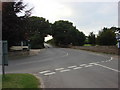
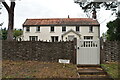
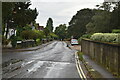
Image Listing (318 Images Found)
Images are licensed for reuse under creativecommons.org/licenses/by-sa/2.0
Image
Details
Distance
10
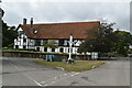
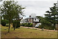
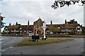
The Whinlands
Modern Thorpeness was conceived by Glencairn Stuart Ogilvie in the early 20th century as a private holiday village.
This is The Whinlands, the houses in which were designed by Frederick Forbes Glennie; those visible on the right of the photo are all grade II listed - for listing particulars from right to left see www.historicengland.org.uk/listing/the-list/list-entry/1228546, www.historicengland.org.uk/listing/the-list/list-entry/1228498 and www.historicengland.org.uk/listing/the-list/list-entry/1228553. The almshouses beyond (see Image) are also grade II listed - see www.historicengland.org.uk/listing/the-list/list-entry/1228271.
Image: © Ian Capper
Taken: 6 Aug 2008
0.04 miles