IMAGES TAKEN NEAR TO
Thorpeness, LEISTON, IP16 4LX
Introduction
This page details the photographs taken nearby to IP16 4LX by members of the Geograph project.
The Geograph project started in 2005 with the aim of publishing, organising and preserving representative images for every square kilometre of Great Britain, Ireland and the Isle of Man.

There are currently over 7.5m images from over14,400 individuals and you can help contribute to the project by visiting https://www.geograph.org.uk
Image Map
Images are licensed for reuse under creativecommons.org/licenses/by-sa/2.0
Notes
- Clicking on the map will re-center to the selected point.
- The higher the marker number, the further away the image location is from the centre of the postcode.
Image Listing (22 Images Found)
Images are licensed for reuse under creativecommons.org/licenses/by-sa/2.0
Image
Details
Distance
1
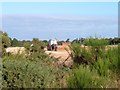
Partables Farm
A tractor has been busy harvesting the crop in one of the fields at Partables Farm, Thorpeness.
Image: © Martin Pearman
Taken: 8 Aug 2007
0.04 miles
4
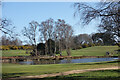
Pond on the Golf Course
At the northern end of Thorpeness Golf Club's course.
Image: © Des Blenkinsopp
Taken: 19 Mar 2022
0.17 miles
5
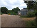
Storage sheds for Thorpeness Golf Club
Large sheds for the tools and equipment needed to maintain the grounds of the course
Image: © David Smith
Taken: 18 Jun 2014
0.18 miles
6
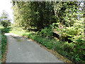
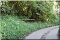
The old Railway Station platform at Thorpeness Halt
The Aldeburgh branch line has been long removed but the platform remains. The line, run by the Great Eastern Railway opened 29.7.1914 and closed 12.9.1966 under British Railways (Eastern Region)
The Aldeburgh branch measured 8.5 miles in length from Saxmundham on the East Suffolk main line.
Image: © Adrian S Pye
Taken: 15 Sep 2014
0.19 miles
7
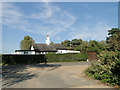
The old crossing gate house at Thorpeness Halt
The railway has long since gone but the gatehouse and the platform remain. http://www.geograph.org.uk/photo/4166662
Image: © Adrian S Pye
Taken: 15 Sep 2014
0.21 miles
8
Thorpeness Halt - the old station platform
Image: © Chris Holifield
Taken: 7 Oct 2021
0.21 miles
9
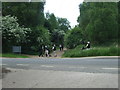
Golfers
Golfers on their way back to the clubhouse near to Thorpeness, Suffolk.
Image: © Keith Evans
Taken: 27 May 2015
0.21 miles
10
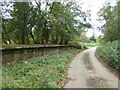
Thorpness Halt platform
All that remains of the halt at Thorpeness on the former Saxmundham to Aldeburgh line.
The line opened in early 1860s by the East Suffolk Railway company. Thorpeness station was downgraded to an unstaffed halt in 1962. The resort failed to develop and the station had always been little used other than serving the nearby golf course.
The Line closed in 1966.
http://www.subbrit.org.uk/sb-sites/stations/t/thorpeness/index.shtml
Image: © John Myers
Taken: 24 May 2009
0.22 miles