IMAGES TAKEN NEAR TO
Charles Adams Close, LEISTON, IP16 4LP
Introduction
This page details the photographs taken nearby to Charles Adams Close, IP16 4LP by members of the Geograph project.
The Geograph project started in 2005 with the aim of publishing, organising and preserving representative images for every square kilometre of Great Britain, Ireland and the Isle of Man.

There are currently over 7.5m images from over14,400 individuals and you can help contribute to the project by visiting https://www.geograph.org.uk
Image Map
Images are licensed for reuse under creativecommons.org/licenses/by-sa/2.0
Notes
- Clicking on the map will re-center to the selected point.
- The higher the marker number, the further away the image location is from the centre of the postcode.
Image Listing (47 Images Found)
Images are licensed for reuse under creativecommons.org/licenses/by-sa/2.0
Image
Details
Distance
2
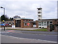
Leiston Fire Station
On King George's Avenue
Image: © Geographer
Taken: 26 Apr 2010
0.10 miles
3

Leiston Fire Station
On King George's Avenue
Image: © Geographer
Taken: 26 Apr 2010
0.10 miles
4
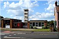
Leiston Fire Station
On the road to Sizewell
Image: © John Myers
Taken: 26 May 2009
0.13 miles
6
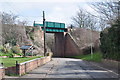
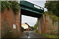
The Aldeburgh Branch
A bridge over the road, this track is the remains of the East Suffolk line's Aldeburgh branch. Opening in June 1859 to Leiston and August 1860 to Aldeburgh.
After closure to passengers on 12th September 1966 the line was lifted 1 mile east of the town. However the remaining 5.5 mile stub is used for Sizewell A nuclear trains, taking spent fuel to Sellafield. All the fuel will have been cleared by 2012, more use may be required with the building of Sizewell C (and D?) after that the future is uncertain.
Image: © Ashley Dace
Taken: 27 Mar 2010
0.14 miles
7

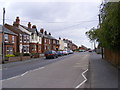
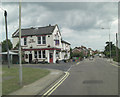
The Crown Public House, Leiston
On King George's Avenue at the junction with Crown Street
http://www.theleistoncrown.co.uk/
Image: © Geographer
Taken: 26 Apr 2010
0.14 miles
9
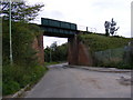
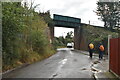
Railway Bridge in Valley Road, Leiston
Road No.U2826
Image: © Geographer
Taken: 18 Jul 2011
0.15 miles