IMAGES TAKEN NEAR TO
Station Road, IP16 4FH
Introduction
This page details the photographs taken nearby to Station Road, IP16 4FH by members of the Geograph project.
The Geograph project started in 2005 with the aim of publishing, organising and preserving representative images for every square kilometre of Great Britain, Ireland and the Isle of Man.

There are currently over 7.5m images from over14,400 individuals and you can help contribute to the project by visiting https://www.geograph.org.uk
Image Map
Images are licensed for reuse under creativecommons.org/licenses/by-sa/2.0
Notes
- Clicking on the map will re-center to the selected point.
- The higher the marker number, the further away the image location is from the centre of the postcode.
Image Listing (193 Images Found)
Images are licensed for reuse under creativecommons.org/licenses/by-sa/2.0
Image
Details
Distance
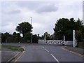
1
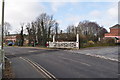
Leiston Level Crossing
A hand operated crossing still exists in Leiston, to the right is the old station. It is the remains of the East Suffolk lines Aldeburgh branch. Opening in June 1859 to Leiston and August 1860 to Aldeburgh.
After closure to passengers on 12th September 1966 the line was lifted 1 mile east of the town. However the remaining 5.5 mile stub was used for Sizewell A nuclear trains, taking spent fuel to Sellafield. All the fuel will have been cleared by 2012, more use may be required with the building of Sizewell C (and d?) after that the future is uncertain.
Image: © Ashley Dace
Taken: 27 Mar 2010
0.01 miles
2
Leiston Level Crossing
A hand operated crossing still exists in Leiston, to the left is the old station. It is the remains of the East Suffolk lines Aldeburgh branch. Opening in June 1859 to Leiston and August 1860 to Aldeburgh.
After closure to passengers on 12th September 1966 the line was lifted 1 mile east of the town. However the remaining 5.5 mile stub was used for Sizewell A nuclear trains, taking spent fuel to Sellafield. All the fuel will have been cleared by 2012, more use may be required with the building of Sizewell C (and d?) after that the future is uncertain.
Image: © Ashley Dace
Taken: 27 Mar 2010
0.02 miles
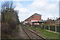
3
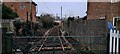
Leiston Works Railway, under restoration
The line seen here curved away from Leiston station (behind the photographer), between the backs of houses to emerge by Leiston library, crossing the road here to enter the Garratt engineering works.
The track seen here has been put in position since the line of the old railway was photographed in 2020: Image
Image: © Christopher Hilton
Taken: 23 Jan 2023
0.03 miles
4
Leiston level crossing
The railway line has been closed to passengers for many years, but has been used recently for transport to the power stations at Sizewell
Image: © David Smith
Taken: 17 Jun 2014
0.03 miles
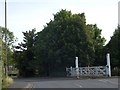
5
Leiston: line of former railway siding
Here a railway siding that left the main line at Leiston station passed behind houses and eventually into the Garratt engineering works. The other end of this can be seen at Image
Some three years later the weeds had been removed and railway track relaid: Image
Image: © Christopher Hilton
Taken: 16 Mar 2020
0.03 miles
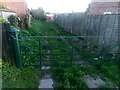
6
Leiston: line of former railway siding
The gate marks the course of a railway siding that left the main line at Leiston station, passed behind houses and eventually ran into the Garratt engineering works. The other end of this siding's course can be seen at Image
Image: © Christopher Hilton
Taken: 16 Mar 2020
0.03 miles
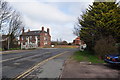
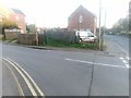
7
Buller Road joining Station Road, Leiston
Image: © Rob Purvis
Taken: 15 Jul 2016
0.03 miles
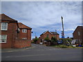
8
Westward Ho, Leiston
Looking towards the junction with the B1122 Abbey Road near the Guide Hut
Image: © Geographer
Taken: 11 Mar 2014
0.04 miles
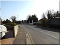
9
Westward Ho, Leiston
At the junction with the B1122 Abbey/Station Road
Road No.U2416
Image: © Geographer
Taken: 18 Jul 2011
0.04 miles
10
Leiston Railway Station
This is the remains of the East Suffolk lines Aldburgh branch. Opening in June 1859 to Leiston and August 1860 to Aldburgh.
After closure to passengers on 12th September 1966 the line was lifted 1 mile east of the town. However the remaining 5.5 mile stub is used for Sizewell A nuclear trains, taking spent fuel to Sellafield. All the fuel will have been cleared by 2012, more use may be required with the building of Sizewell C (and d?) after that the future is uncertain.
Image: © Ashley Dace
Taken: 27 Mar 2010
0.04 miles