IMAGES TAKEN NEAR TO
High Green, LEISTON, IP16 4ET
Introduction
This page details the photographs taken nearby to High Green, IP16 4ET by members of the Geograph project.
The Geograph project started in 2005 with the aim of publishing, organising and preserving representative images for every square kilometre of Great Britain, Ireland and the Isle of Man.

There are currently over 7.5m images from over14,400 individuals and you can help contribute to the project by visiting https://www.geograph.org.uk
Image Map
Images are licensed for reuse under creativecommons.org/licenses/by-sa/2.0
Notes
- Clicking on the map will re-center to the selected point.
- The higher the marker number, the further away the image location is from the centre of the postcode.
Image Listing (218 Images Found)
Images are licensed for reuse under creativecommons.org/licenses/by-sa/2.0
Image
Details
Distance
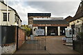
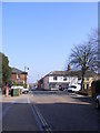
2
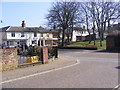
Dinsdale Road, Leiston
At the junction with the B1122 Main Street
Image: © Geographer
Taken: 15 Mar 2012
0.02 miles
5
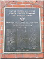
Memorial to the Men of the 357 fighter group
Memorial to the Men of the 357 fighter group Leiston Suffolk. For more info on the airfield see http://en.wikipedia.org/wiki/RAF_Leiston and for photos linked to the airfield see http://www.geograph.org.uk/photo/1119719 http://www.geograph.org.uk/photo/1119721 http://www.geograph.org.uk/photo/1119729
Image: © Keith Evans
Taken: 20 Nov 2007
0.02 miles
8
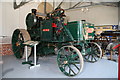
Long Shop Museum - Suffolk Punch Tractor
A direct haulage ploughing traction engine (rather than a cable haulage ploughing engine) built in 1919 by Richard Garrett & Sons Ltd, Leiston and known as 'The Suffolk Punch'. The engine is a 5 NHP compound and it weighs 7 tons. This is the sole survivor of its type and it is fitting that it is on display where it was built.
Image: © Chris Allen
Taken: 11 Jun 2006
0.03 miles
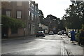
9
B1122 Main Street, Leiston
Looking towards the junction with Valley Road at the junction with Dinsdale Road
Image: © Geographer
Taken: 15 Mar 2012
0.03 miles
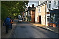
10
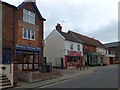
High Street and Mafeking Place, Leiston
Presumably Mafeking Place celebrates the relief of Mafeking during the Boer War and dates the construction of the area
Image: © David Smith
Taken: 18 Jun 2014
0.03 miles