IMAGES TAKEN NEAR TO
Lovetofts Drive, IPSWICH, IP1 5PG
Introduction
This page details the photographs taken nearby to Lovetofts Drive, IP1 5PG by members of the Geograph project.
The Geograph project started in 2005 with the aim of publishing, organising and preserving representative images for every square kilometre of Great Britain, Ireland and the Isle of Man.

There are currently over 7.5m images from over14,400 individuals and you can help contribute to the project by visiting https://www.geograph.org.uk
Image Map
Images are licensed for reuse under creativecommons.org/licenses/by-sa/2.0
Notes
- Clicking on the map will re-center to the selected point.
- The higher the marker number, the further away the image location is from the centre of the postcode.
Image Listing (18 Images Found)
Images are licensed for reuse under creativecommons.org/licenses/by-sa/2.0
Image
Details
Distance
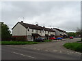
2
Maudslay Road
A residential street off Lovetofts Drive in the White House area of Ipswich.
Image: © Andrew Hill
Taken: 9 May 2009
0.04 miles
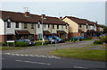
7

Lovetofts Drive
A residential part of White House, leading north towards industrial and business parks.
Image: © Andrew Hill
Taken: 9 May 2009
0.16 miles
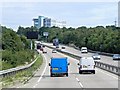
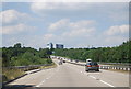
8
A14 northbound
Bypassing Ipswich, which is to the right.
Image: © Robin Webster
Taken: 11 Aug 2018
0.16 miles

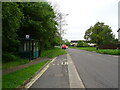
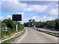
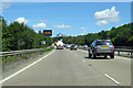
10
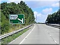
A14 Approaching Junction 53 (Whitehouse)
Image: © David Dixon
Taken: 3 Aug 2013
0.18 miles