IMAGES TAKEN NEAR TO
Diamond Close, IPSWICH, IP1 5HN
Introduction
This page details the photographs taken nearby to Diamond Close, IP1 5HN by members of the Geograph project.
The Geograph project started in 2005 with the aim of publishing, organising and preserving representative images for every square kilometre of Great Britain, Ireland and the Isle of Man.

There are currently over 7.5m images from over14,400 individuals and you can help contribute to the project by visiting https://www.geograph.org.uk
Image Map
Images are licensed for reuse under creativecommons.org/licenses/by-sa/2.0
Notes
- Clicking on the map will re-center to the selected point.
- The higher the marker number, the further away the image location is from the centre of the postcode.
Image Listing (19 Images Found)
Images are licensed for reuse under creativecommons.org/licenses/by-sa/2.0
Image
Details
Distance
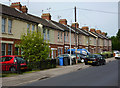
1

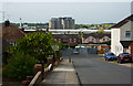
High View Road
Distinctive houses on the west side of the street.
Image: © Andrew Hill
Taken: 9 May 2009
0.05 miles


5
High View Road
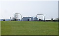
Looking south towards the junction with Henniker Road. The beet factory can be seen in the distance.
Image: © Andrew Hill
Taken: 9 May 2009
0.12 miles
6
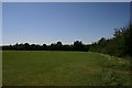
Playing fields, Ipswich
These playing fields are at the junction of Lovetofts Drive and Bramford Lane.
Image: © Bob Jones
Taken: 28 Jun 2006
0.12 miles
8
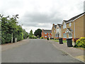
Houses on Henniker Road
A long residential street parallel to Bramford Road. Beyond the last house in view it becomes a cul-de-sac.
Image: © Andrew Hill
Taken: 9 May 2009
0.15 miles
9

Track off Henniker Road
This short track leads from Henniker Road up to the playing fields shown in http://www.geograph.org.uk/photo/1205893 .
Image: © Oxymoron
Taken: 15 Mar 2009
0.16 miles
10

Lovetofts Drive
A residential part of White House, leading north towards industrial and business parks.
Image: © Andrew Hill
Taken: 9 May 2009
0.16 miles