IMAGES TAKEN NEAR TO
Brett Close, IPSWICH, IP1 5ES
Introduction
This page details the photographs taken nearby to Brett Close, IP1 5ES by members of the Geograph project.
The Geograph project started in 2005 with the aim of publishing, organising and preserving representative images for every square kilometre of Great Britain, Ireland and the Isle of Man.

There are currently over 7.5m images from over14,400 individuals and you can help contribute to the project by visiting https://www.geograph.org.uk
Image Map
Images are licensed for reuse under creativecommons.org/licenses/by-sa/2.0
Notes
- Clicking on the map will re-center to the selected point.
- The higher the marker number, the further away the image location is from the centre of the postcode.
Image Listing (28 Images Found)
Images are licensed for reuse under creativecommons.org/licenses/by-sa/2.0
Image
Details
Distance
1
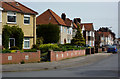
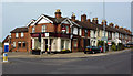
Eustace Road
A residential street parallel to the railway line.
Image: © Andrew Hill
Taken: 9 May 2009
0.02 miles
2
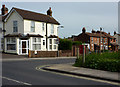
Pitcairn Road
At the junction with Bramford Road.
Image: © Andrew Hill
Taken: 9 May 2009
0.07 miles
3
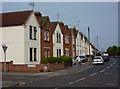
Houses on Bramford Lane
West of the railway line as the road heads away from Ipswich town centre.
Image: © Andrew Hill
Taken: 9 May 2009
0.10 miles
4
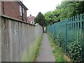
Footpath alongside the railway
Links Bramford Lane with Edward Close.
Image: © Jonathan Thacker
Taken: 15 May 2022
0.11 miles
5
Junction of Sproughton Road and Bramford Road
Just west of the railway bridge. The junction is controlled with traffic lights.
Image: © Andrew Hill
Taken: 9 May 2009
0.11 miles
6
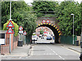
Railway bridge in Bramford Lane, Westbourne
Image: © Adrian S Pye
Taken: 23 Jun 2015
0.11 miles
7
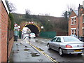
Road tunnel
Bramford Road Ipswich, Suffolk cuts through the railway embankment in a small tunnel like fashion.
Image: © Keith Evans
Taken: 5 Feb 2009
0.11 miles
8
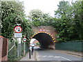
Bramford Lane railway bridge
Despite the vegetation on top of the bridge this carries a very busy railway line.
Image: © Jonathan Thacker
Taken: 12 May 2022
0.12 miles
9
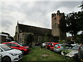
Church of St. Thomas, Ipswich
Designed by N.F. Cachemaille-Day https://en.wikipedia.org/wiki/Nugent_Cachemaille-Day 1936-7 https://historicengland.org.uk/listing/the-list/list-entry/1400120?section=official-listing
Image: © Jonathan Thacker
Taken: 2 Aug 2021
0.12 miles
10
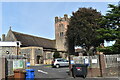
Church of St. Thomas, Westbourne, Ipswich
The church was built in 1938 to replace a tin chapel, used since 1902, and accommodate a growing population in this north-western suburb of Ipswich. It was designed by architect Nugent Francis Cachemaille-Day (1896-1976) and is a Grade II Listed Building.
Image: © Simon Mortimer
Taken: 12 Sep 2020
0.12 miles