IMAGES TAKEN NEAR TO
Mumford Road, IPSWICH, IP1 5DE
Introduction
This page details the photographs taken nearby to Mumford Road, IP1 5DE by members of the Geograph project.
The Geograph project started in 2005 with the aim of publishing, organising and preserving representative images for every square kilometre of Great Britain, Ireland and the Isle of Man.

There are currently over 7.5m images from over14,400 individuals and you can help contribute to the project by visiting https://www.geograph.org.uk
Image Map
Images are licensed for reuse under creativecommons.org/licenses/by-sa/2.0
Notes
- Clicking on the map will re-center to the selected point.
- The higher the marker number, the further away the image location is from the centre of the postcode.
Image Listing (28 Images Found)
Images are licensed for reuse under creativecommons.org/licenses/by-sa/2.0
Image
Details
Distance
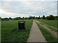
2
Allotments off Bramford Lane, Ipswich
Image: © Jonathan Thacker
Taken: 12 May 2022
0.11 miles
3
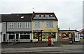
Estate Stores on Bramford Lane
Showing position of Postbox No.IP1 1001.
See Image] for postbox.
Image: © JThomas
Taken: 12 May 2023
0.14 miles
5
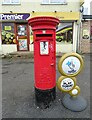
Elizabeth II postbox on Bramford Lane
Postbox No.IP1 1001.
See Image] for context.
Image: © JThomas
Taken: 12 May 2023
0.15 miles
6
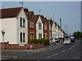
Houses on Bramford Lane
West of the railway line as the road heads away from Ipswich town centre.
Image: © Andrew Hill
Taken: 9 May 2009
0.16 miles
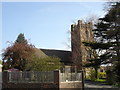
9
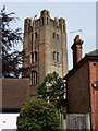
Church tower
A glimpse of the tower of the Church of St Thomas the Apostle, seen from Cromer Road.
Image: © Andrew Hill
Taken: 9 May 2009
0.19 miles
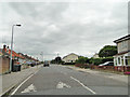
10
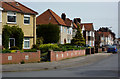
Eustace Road
A residential street parallel to the railway line.
Image: © Andrew Hill
Taken: 9 May 2009
0.19 miles