IMAGES TAKEN NEAR TO
Jovian Way, IPSWICH, IP1 5AT
Introduction
This page details the photographs taken nearby to Jovian Way, IP1 5AT by members of the Geograph project.
The Geograph project started in 2005 with the aim of publishing, organising and preserving representative images for every square kilometre of Great Britain, Ireland and the Isle of Man.

There are currently over 7.5m images from over14,400 individuals and you can help contribute to the project by visiting https://www.geograph.org.uk
Image Map
Images are licensed for reuse under creativecommons.org/licenses/by-sa/2.0
Notes
- Clicking on the map will re-center to the selected point.
- The higher the marker number, the further away the image location is from the centre of the postcode.
Image Listing (13 Images Found)
Images are licensed for reuse under creativecommons.org/licenses/by-sa/2.0
Image
Details
Distance
1
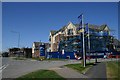
Blakenham Park
Blakenham Park Ipswich, Suffolk. See http://www.geograph.org.uk/photo/193120 for view taken of the same building two and a half years ago.
Image: © Keith Evans
Taken: 19 Jan 2009
0.07 miles
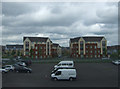
4
Blakenham Park, Ipswich
A new housing estate on the western outskirts of Ipswich.
Image: © Bob Jones
Taken: 28 Jun 2006
0.13 miles
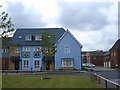
5
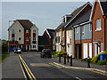
Modern town houses
Just off Bramford Road.
Image: © Andrew Hill
Taken: 9 May 2009
0.14 miles
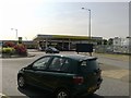
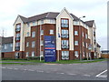
8
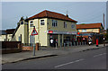
Shop on Bramford Road
A Tesco Express with a postbox at the front.
Image: © Andrew Hill
Taken: 9 May 2009
0.18 miles
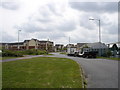
9
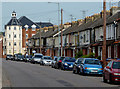
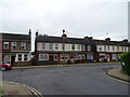
Bramford Road
Traditional terraced houses line the road most of the way out of Ipswich. There are some modern flats just beyond the turn for Adair Road.
Image: © Andrew Hill
Taken: 9 May 2009
0.19 miles