IMAGES TAKEN NEAR TO
Sproughton Road, IPSWICH, IP1 5AF
Introduction
This page details the photographs taken nearby to Sproughton Road, IP1 5AF by members of the Geograph project.
The Geograph project started in 2005 with the aim of publishing, organising and preserving representative images for every square kilometre of Great Britain, Ireland and the Isle of Man.

There are currently over 7.5m images from over14,400 individuals and you can help contribute to the project by visiting https://www.geograph.org.uk
Image Map
Images are licensed for reuse under creativecommons.org/licenses/by-sa/2.0
Notes
- Clicking on the map will re-center to the selected point.
- The higher the marker number, the further away the image location is from the centre of the postcode.
Image Listing (42 Images Found)
Images are licensed for reuse under creativecommons.org/licenses/by-sa/2.0
Image
Details
Distance
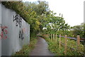
4
Gipping footpath
The footpath towards Ipswich bound by fences at this point.
Image: © Andrew Hill
Taken: 8 Jan 2010
0.12 miles
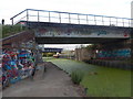
5
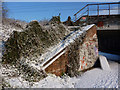
Railway embankment and bridge
The northern end of the railway bridge over the Gipping.
Image: © Andrew Hill
Taken: 8 Jan 2010
0.13 miles
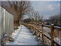
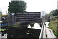
6
River Gipping Flood Barrier
Here in its raised state.
Image: © N Chadwick
Taken: 18 Sep 2011
0.13 miles
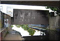
9
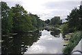
River Gipping
Looking upstream to the flood barrier.
Image: © N Chadwick
Taken: 18 Sep 2011
0.14 miles
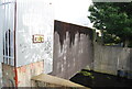
10
Railway bridges, Sproughton
At the edge of Sproughton parish.
Image: © Hamish Griffin
Taken: 21 Jul 2017
0.14 miles