IMAGES TAKEN NEAR TO
Park Road, ALDEBURGH, IP15 5EX
Introduction
This page details the photographs taken nearby to Park Road, IP15 5EX by members of the Geograph project.
The Geograph project started in 2005 with the aim of publishing, organising and preserving representative images for every square kilometre of Great Britain, Ireland and the Isle of Man.

There are currently over 7.5m images from over14,400 individuals and you can help contribute to the project by visiting https://www.geograph.org.uk
Image Map
Images are licensed for reuse under creativecommons.org/licenses/by-sa/2.0
Notes
- Clicking on the map will re-center to the selected point.
- The higher the marker number, the further away the image location is from the centre of the postcode.
Image Listing (257 Images Found)
Images are licensed for reuse under creativecommons.org/licenses/by-sa/2.0
Image
Details
Distance
1
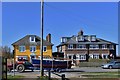
Aldeburgh High Street: Mock Georgian house at the beginning of the high street
Image: © Michael Garlick
Taken: 22 Mar 2016
0.02 miles
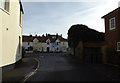
2
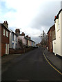
Park Road, Aldeburgh
At the junction with the A1094 High Street
Image: © Geographer
Taken: 27 Jan 2015
0.02 miles
3
![Aldeburgh houses [20]](https://s2.geograph.org.uk/geophotos/06/73/03/6730334_88c960a1_120x120.jpg)
Aldeburgh houses [20]
Shipway, number 239 High Street, and Cranstons, number 241 High Street, are a pair of early 19th century houses in brick. Listed, grade II, with details at: https://historicengland.org.uk/listing/the-list/list-entry/1269746
Aldeburgh is a coastal town, some 20 miles north east of Ipswich and 23 miles south of Lowestoft. Although there are traces of Roman and Saxon occupation, Aldeburgh was a little fishing village until the shifting coastline opened up a sheltered harbour which became a thriving ship building centre. As the River Alde silted up the town’s fortunes waned, and it survived as a fishing village until the 19th Century when it became a fashionable seaside resort. A classical music festival takes place at nearby Snape Maltings each year.
Image: © Michael Dibb
Taken: 10 Sep 2020
0.02 miles
4
A1094 High Street, Aldeburgh
At the junction with Park Road
Image: © Geographer
Taken: 27 Jan 2015
0.03 miles
5
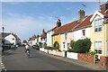
The End of Aldeburgh High Street
The A1094, Aldeburgh High Street, ends about where the cyclist is.
It continues as Slaughden Road and loses its red colour on the map.
Nice colourful houses in this town.
Image: © Des Blenkinsopp
Taken: 1 Jul 2015
0.03 miles
6
![Aldeburgh houses [19]](https://s3.geograph.org.uk/geophotos/06/73/03/6730331_94ef702f_120x120.jpg)
Aldeburgh houses [19]
The Sun Trap, number 233 High Street and End Cottage, number 235 High Street, were built circa 1840. Constructed in brick. Listed, grade II, with details at: https://historicengland.org.uk/listing/the-list/list-entry/1269745
Aldeburgh is a coastal town, some 20 miles north east of Ipswich and 23 miles south of Lowestoft. Although there are traces of Roman and Saxon occupation, Aldeburgh was a little fishing village until the shifting coastline opened up a sheltered harbour which became a thriving ship building centre. As the River Alde silted up the town’s fortunes waned, and it survived as a fishing village until the 19th Century when it became a fashionable seaside resort. A classical music festival takes place at nearby Snape Maltings each year.
Image: © Michael Dibb
Taken: 10 Sep 2020
0.03 miles
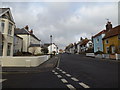
7
Park Road, Aldeburgh
At the junction with the A1094 High Street
Image: © Geographer
Taken: 3 Feb 2015
0.03 miles
8
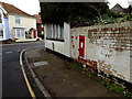
South End George V Postbox
On Park Road at the junction with the A1094 High Street
Postbox No.IP15 4601D
Image: © Geographer
Taken: 27 Jan 2015
0.03 miles
9
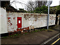
South End George V Postbox
On Park Road at the junction with the A1094 High Street
Postbox No.IP15 4601D
Image: © Geographer
Taken: 27 Jan 2015
0.03 miles
10
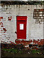
South End George V Postbox
On Park Road at the junction with the A1094 High Street
Postbox No.IP15 4601D
Image: © Geographer
Taken: 27 Jan 2015
0.03 miles