IMAGES TAKEN NEAR TO
Coastguard Court, High Street, ALDEBURGH, IP15 5DR
Introduction
This page details the photographs taken nearby to Coastguard Court, High Street, IP15 5DR by members of the Geograph project.
The Geograph project started in 2005 with the aim of publishing, organising and preserving representative images for every square kilometre of Great Britain, Ireland and the Isle of Man.

There are currently over 7.5m images from over14,400 individuals and you can help contribute to the project by visiting https://www.geograph.org.uk
Image Map
Images are licensed for reuse under creativecommons.org/licenses/by-sa/2.0
Notes
- Clicking on the map will re-center to the selected point.
- The higher the marker number, the further away the image location is from the centre of the postcode.
Image Listing (204 Images Found)
Images are licensed for reuse under creativecommons.org/licenses/by-sa/2.0
Image
Details
Distance
1
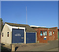
Coastguard Station, Aldeburgh, Suffolk
Image: © John Winfield
Taken: 27 Oct 2005
0.02 miles
3
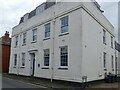
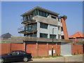
Monarch House, Aldeburgh
This former telecommunications centre is now a block of flats.
It was a repeater station that connected the submarine telephone cables under the North Sea to the landline cables.
In 1922 that the first telephone cable was laid between Aldeburgh and Domburg in The Netherlands.
A blue plaque commemorates the historic importance of this building https://www.geograph.org.uk/photo/7313740 .
Image: © Robin Drayton
Taken: 27 Sep 2022
0.03 miles
4
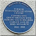
Blue plaque on Monarch House, Aldeburgh
https://www.geograph.org.uk/photo/7313644
Image: © Robin Drayton
Taken: 27 Sep 2022
0.03 miles
5
Modern building, 29 Brudenell Street, Aldeburgh
I'm not sure whether this is a single house, a block of flats or something else, but it's certainly interesting !
Image: © John Brightley
Taken: 8 Aug 2004
0.03 miles
6
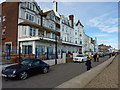
The Brudenell Hotel on Aldeburgh seafront
Image: © Richard Law
Taken: 13 Oct 2012
0.04 miles
7
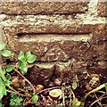
Cut Mark Aldeburgh 270 High Street?
Cut Mark 270 High Street Aldeburgh, S Face.
Image: © Cud05
Taken: 21 May 2016
0.04 miles
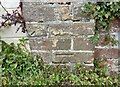
8
Ordnance Survey Cut Mark
This OS cut mark can be found on No270 High Street. It marks a point 2.6883m above mean sea level.
Image: © Adrian Dust
Taken: 1 May 2018
0.04 miles
9
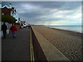
Crag Path
View north along Aldeburgh beach, with a threatening sky over Thorpeness in the distance.
Image: © Tim Marchant
Taken: 28 Aug 2010
0.05 miles
10
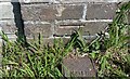
Aldeburgh, 270 High Street
The benchmark is cut into the south facing wall of the property.
Image: © Mel Towler
Taken: 3 Jul 2022
0.05 miles