IMAGES TAKEN NEAR TO
Millers View, IPSWICH, IP1 4QB
Introduction
This page details the photographs taken nearby to Millers View, IP1 4QB by members of the Geograph project.
The Geograph project started in 2005 with the aim of publishing, organising and preserving representative images for every square kilometre of Great Britain, Ireland and the Isle of Man.

There are currently over 7.5m images from over14,400 individuals and you can help contribute to the project by visiting https://www.geograph.org.uk
Image Map
Images are licensed for reuse under creativecommons.org/licenses/by-sa/2.0
Notes
- Clicking on the map will re-center to the selected point.
- The higher the marker number, the further away the image location is from the centre of the postcode.
Image Listing (65 Images Found)
Images are licensed for reuse under creativecommons.org/licenses/by-sa/2.0
Image
Details
Distance
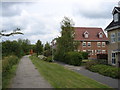

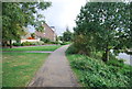
6

Bend in the river and modern riverside houses
The River Gipping towards more built up parts of Ipswich.
Image: © Andrew Hill
Taken: 8 Jan 2010
0.07 miles
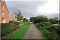
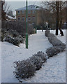
7

New houses near the river
Seen from the Gipping footpath with snow on the ground.
Image: © Andrew Hill
Taken: 8 Jan 2010
0.07 miles
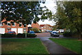
8
New residential development
Modern houses near the banks of the river Gipping.
Image: © Andrew Hill
Taken: 8 Jan 2010
0.07 miles
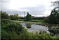
10
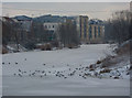
Ice covered river Gipping
Gulls and other birds walking on the ice, with modern Ipswich flats beyond.
Image: © Andrew Hill
Taken: 8 Jan 2010
0.09 miles