IMAGES TAKEN NEAR TO
Henley Road, IPSWICH, IP1 4NX
Introduction
This page details the photographs taken nearby to Henley Road, IP1 4NX by members of the Geograph project.
The Geograph project started in 2005 with the aim of publishing, organising and preserving representative images for every square kilometre of Great Britain, Ireland and the Isle of Man.

There are currently over 7.5m images from over14,400 individuals and you can help contribute to the project by visiting https://www.geograph.org.uk
Image Map
Images are licensed for reuse under creativecommons.org/licenses/by-sa/2.0
Notes
- Clicking on the map will re-center to the selected point.
- The higher the marker number, the further away the image location is from the centre of the postcode.
Image Listing (38 Images Found)
Images are licensed for reuse under creativecommons.org/licenses/by-sa/2.0
Image
Details
Distance
1
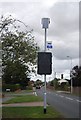
Solar powered
A solar powered road narrows sign.
Image: © N Chadwick
Taken: 18 Sep 2011
0.01 miles
8
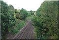
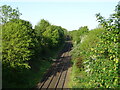
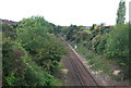
East Suffolk Railway from the Henley Road overbridge
Looking east towards Westerfield. The railway opened in 1859 and linked Ipswich and Yarmouth, with branches to Aldeburgh, Framlingham and Lowestoft.
Image: © Simon Mortimer
Taken: 20 Aug 2020
0.11 miles