IMAGES TAKEN NEAR TO
Dale Hall Lane, IPSWICH, IP1 4LY
Introduction
This page details the photographs taken nearby to Dale Hall Lane, IP1 4LY by members of the Geograph project.
The Geograph project started in 2005 with the aim of publishing, organising and preserving representative images for every square kilometre of Great Britain, Ireland and the Isle of Man.

There are currently over 7.5m images from over14,400 individuals and you can help contribute to the project by visiting https://www.geograph.org.uk
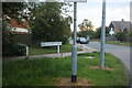
Image Map
Images are licensed for reuse under creativecommons.org/licenses/by-sa/2.0
Notes
- Clicking on the map will re-center to the selected point.
- The higher the marker number, the further away the image location is from the centre of the postcode.
Image Listing (29 Images Found)
Images are licensed for reuse under creativecommons.org/licenses/by-sa/2.0
Image
Details
Distance
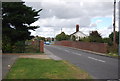
1
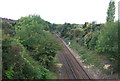
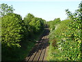
Bridge over the East Suffolk railway line, Dale Hall, Lane
Image: © Simon Mortimer
Taken: 20 Aug 2020
0.03 miles
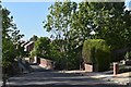
3
The Ascension Church, Castle Hill
This is a chapel of ease built in the seventies for the parish church at Whitton http://www.geograph.org.uk/photo/61166 .
Image: © Oxymoron
Taken: 9 Jan 2009
0.09 miles
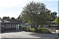
4
The Ascension Ipswich
The Ascension Ipswich, Suffolk. For more info see http://www.suffolkchurches.co.uk/ipsascension.htm
Image: © Keith Evans
Taken: 16 Feb 2009
0.10 miles