IMAGES TAKEN NEAR TO
Bramford Lane, IPSWICH, IP1 4DF
Introduction
This page details the photographs taken nearby to Bramford Lane, IP1 4DF by members of the Geograph project.
The Geograph project started in 2005 with the aim of publishing, organising and preserving representative images for every square kilometre of Great Britain, Ireland and the Isle of Man.

There are currently over 7.5m images from over14,400 individuals and you can help contribute to the project by visiting https://www.geograph.org.uk
Image Map
Images are licensed for reuse under creativecommons.org/licenses/by-sa/2.0
Notes
- Clicking on the map will re-center to the selected point.
- The higher the marker number, the further away the image location is from the centre of the postcode.
Image Listing (52 Images Found)
Images are licensed for reuse under creativecommons.org/licenses/by-sa/2.0
Image
Details
Distance
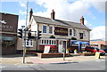
1
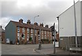
Terraced houses on Chevalier Street, Ipswich
Image: © David Howard
Taken: 22 May 2022
0.14 miles
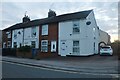
2
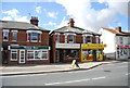
British Red Cross on Chevalier Street, Ipswich
Image: © David Howard
Taken: 22 May 2022
0.14 miles
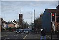
6
Junction of Yarmouth Road and Bramford Road
Image: © Trevor Harris
Taken: 15 Feb 2013
0.15 miles
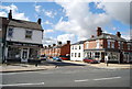
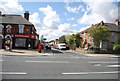
7
Shops on Norwich Rd
A small parade of shops.
Image: © N Chadwick
Taken: 18 Sep 2011
0.15 miles
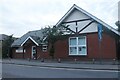
9
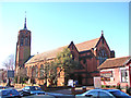
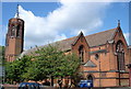
All Saints church in Chevallier Street, Ipswich
Image: © Adrian S Pye
Taken: 12 Jan 2008
0.16 miles