IMAGES TAKEN NEAR TO
High Street, STOWMARKET, IP14 6QP
Introduction
This page details the photographs taken nearby to High Street, IP14 6QP by members of the Geograph project.
The Geograph project started in 2005 with the aim of publishing, organising and preserving representative images for every square kilometre of Great Britain, Ireland and the Isle of Man.

There are currently over 7.5m images from over14,400 individuals and you can help contribute to the project by visiting https://www.geograph.org.uk
Image Map
Images are licensed for reuse under creativecommons.org/licenses/by-sa/2.0
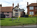
Notes
- Clicking on the map will re-center to the selected point.
- The higher the marker number, the further away the image location is from the centre of the postcode.
Image Listing (294 Images Found)
Images are licensed for reuse under creativecommons.org/licenses/by-sa/2.0
Image
Details
Distance
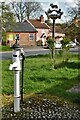
4
Debenham Village Pump: The location within the High Street
Image: © Michael Garlick
Taken: 5 Apr 2021
0.01 miles
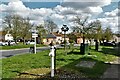
5
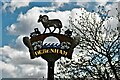
Debenham High Street: The Village Sign
Image: © Michael Garlick
Taken: 5 Apr 2021
0.01 miles
6
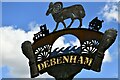
Debenham High Street with village sign
Image: © Michael Garlick
Taken: 5 Apr 2021
0.01 miles
8
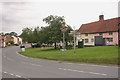
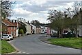
B1077 High Street, Debenham
At the junction with Cross Green
Image: © Geographer
Taken: 29 Aug 2015
0.01 miles
9
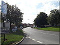
Roadsign & High Street sign
On the B1077 High Street at the junction with Cross Green
Image: © Geographer
Taken: 29 Aug 2015
0.01 miles
10
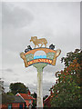
Debenham village sign
The shape of the sign reflects the bridge over the River Deben. It is surmounted by a golden ram symbolising the 17th century wealth obtained in Debenham from the lucrative wool trade. The church of St Mary Magdalene stands on the bridge in silhouette, similarly, on the other side is the old Guildhall which was built in the 17th century on the site of a market cross. Wheat sheaves decorate the outer edge of the sign in deference to the agricultural heritage of the area. https://www.geograph.org.uk/photo/6760230
Image: © Adrian S Pye
Taken: 4 Oct 2008
0.01 miles