IMAGES TAKEN NEAR TO
Derrybrook Lane, STOWMARKET, IP14 6PU
Introduction
This page details the photographs taken nearby to Derrybrook Lane, IP14 6PU by members of the Geograph project.
The Geograph project started in 2005 with the aim of publishing, organising and preserving representative images for every square kilometre of Great Britain, Ireland and the Isle of Man.

There are currently over 7.5m images from over14,400 individuals and you can help contribute to the project by visiting https://www.geograph.org.uk
Image Map
Images are licensed for reuse under creativecommons.org/licenses/by-sa/2.0
Notes
- Clicking on the map will re-center to the selected point.
- The higher the marker number, the further away the image location is from the centre of the postcode.
Image Listing (7 Images Found)
Images are licensed for reuse under creativecommons.org/licenses/by-sa/2.0
Image
Details
Distance
1
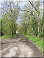
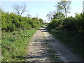
Bridleway
Bridleway near to Wetherup Street, Suffolk.
Image: © Keith Evans
Taken: 22 Apr 2012
0.05 miles
2
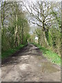
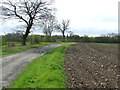
Stony Lane
Stony Lane near to Debenham, Suffolk looking west.
Image: © Keith Evans
Taken: 22 Apr 2012
0.15 miles
3
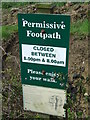
Closed Between 8.00 Pm and 8.00Am
Permissive footpath sign with opening times near to Wetherup Street, Suffolk.
Image: © Keith Evans
Taken: 22 Apr 2012
0.15 miles
4
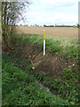
Drain Marker
Field drain marker and drain exit into ditch near to Debenham, Suffolk.
Image: © Keith Evans
Taken: 22 Apr 2012
0.16 miles
5
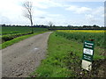
Permissive Footpath
Permissive footpath and sign near to Wetherup Street, Suffolk.
Image: © Keith Evans
Taken: 22 Apr 2012
0.17 miles
6
Footpath
Footpath leading to Stony Lane near to Debenham, Suffolk.
Image: © Keith Evans
Taken: 22 Apr 2012
0.20 miles
7
Track to Brice's Farm
Also a bridleway.
Image: © Jonathan Billinger
Taken: 1 May 2007
0.22 miles