IMAGES TAKEN NEAR TO
Aspall, STOWMARKET, IP14 6NT
Introduction
This page details the photographs taken nearby to IP14 6NT by members of the Geograph project.
The Geograph project started in 2005 with the aim of publishing, organising and preserving representative images for every square kilometre of Great Britain, Ireland and the Isle of Man.

There are currently over 7.5m images from over14,400 individuals and you can help contribute to the project by visiting https://www.geograph.org.uk
Image Map
Images are licensed for reuse under creativecommons.org/licenses/by-sa/2.0
Notes
- Clicking on the map will re-center to the selected point.
- The higher the marker number, the further away the image location is from the centre of the postcode.
Image Listing (1 Images Found)
Images are licensed for reuse under creativecommons.org/licenses/by-sa/2.0
Image
Details
Distance
1
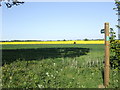
Flat Suffolk countryside
This level land is at 60m altitude, an average height for the dissected East Suffolk plateau. The footpath makes its way over the fields to Aspall House.
Image: © Jonathan Billinger
Taken: 1 May 2007
0.09 miles