IMAGES TAKEN NEAR TO
East End Road, STOWMARKET, IP14 6AS
Introduction
This page details the photographs taken nearby to East End Road, IP14 6AS by members of the Geograph project.
The Geograph project started in 2005 with the aim of publishing, organising and preserving representative images for every square kilometre of Great Britain, Ireland and the Isle of Man.

There are currently over 7.5m images from over14,400 individuals and you can help contribute to the project by visiting https://www.geograph.org.uk
Image Map
Images are licensed for reuse under creativecommons.org/licenses/by-sa/2.0
Notes
- Clicking on the map will re-center to the selected point.
- The higher the marker number, the further away the image location is from the centre of the postcode.
Image Listing (5 Images Found)
Images are licensed for reuse under creativecommons.org/licenses/by-sa/2.0
Image
Details
Distance
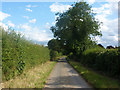
2
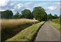
East End Road
A little dead-end lane northeast of Stonham Aspal.
Image: © Andrew Hill
Taken: 25 Jul 2009
0.16 miles
4
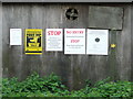
Six Signs
Sign at Park Farm near to Pettaugh, Suffolk.
Image: © Keith Evans
Taken: 6 May 2012
0.19 miles
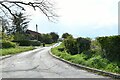
5
On East End Road
A dead-end lane northeast of Stonham Aspal. This is near the sharp corner.
Image: © Andrew Hill
Taken: 25 Jul 2009
0.24 miles