IMAGES TAKEN NEAR TO
Mendlesham Green, STOWMARKET, IP14 5TF
Introduction
This page details the photographs taken nearby to IP14 5TF by members of the Geograph project.
The Geograph project started in 2005 with the aim of publishing, organising and preserving representative images for every square kilometre of Great Britain, Ireland and the Isle of Man.

There are currently over 7.5m images from over14,400 individuals and you can help contribute to the project by visiting https://www.geograph.org.uk
Image Map
Images are licensed for reuse under creativecommons.org/licenses/by-sa/2.0
Notes
- Clicking on the map will re-center to the selected point.
- The higher the marker number, the further away the image location is from the centre of the postcode.
Image Listing (20 Images Found)
Images are licensed for reuse under creativecommons.org/licenses/by-sa/2.0
Image
Details
Distance
1
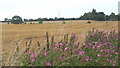
Great willow herb with golden fields behind
The crop was gathered into ridges which can just be made out.
Image: © Andrew Hill
Taken: 19 Jul 2008
0.07 miles
2
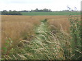
Footpath towards the infant Gipping in its shallow valley
The Gipping rises in open land between the villages of Mendlesham and Mendlesham Green, flowing towards Ipswich.
Image: © Andrew Hill
Taken: 19 Jul 2008
0.09 miles
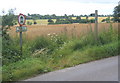
3
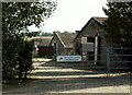
Old Hundred Lane Farm, Mendlesham Green, Suffolk
Image: © Robert Edwards
Taken: 6 Sep 2006
0.10 miles

5
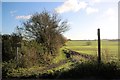
Old Hundred Lane
This restricted byway leads south-east from the minor road between Stowupland and Mendlesham. The rather scruffy sign on the left indicates that motor vehicles are prohibited, 'except for permit holders'. The byway is part of the Mid Suffolk long-distance footpath.
Image: © Bob Jones
Taken: 25 Nov 2015
0.13 miles
6
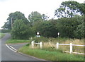
Turn right for Mendlesham Green
The "main" road continues towards Mendlesham.
Image: © Andrew Hill
Taken: 19 Jul 2008
0.13 miles

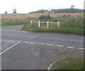
8
Byway junction west of Mendlesham Green
Even the permit holders must think twice before taking a vehicle....
Image: © Andrew Hill
Taken: 19 Jul 2008
0.14 miles
9
Road junction near Mendlesham Green
Turn sharp right for Mendlesham. Looking northwest, a small area of woodland called The Thickett on 1:25,000 map in the background.
Image: © Andrew Hill
Taken: 19 Jul 2008
0.15 miles
