IMAGES TAKEN NEAR TO
Hockey Hill, STOWMARKET, IP14 5PL
Introduction
This page details the photographs taken nearby to Hockey Hill, IP14 5PL by members of the Geograph project.
The Geograph project started in 2005 with the aim of publishing, organising and preserving representative images for every square kilometre of Great Britain, Ireland and the Isle of Man.

There are currently over 7.5m images from over14,400 individuals and you can help contribute to the project by visiting https://www.geograph.org.uk
Image Map
Images are licensed for reuse under creativecommons.org/licenses/by-sa/2.0
Notes
- Clicking on the map will re-center to the selected point.
- The higher the marker number, the further away the image location is from the centre of the postcode.
Image Listing (31 Images Found)
Images are licensed for reuse under creativecommons.org/licenses/by-sa/2.0
Image
Details
Distance
2
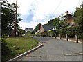
Entrance to Wetheringsett V.C.P. School
Off Hockey Hill
Image: © Geographer
Taken: 1 Aug 2015
0.16 miles
3

Wetheringsett V.C.P. School sign
Off Hockey Hill
Image: © Geographer
Taken: 1 Aug 2015
0.16 miles
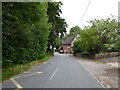
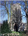
10
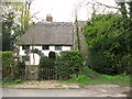
Mill Cottage, Wetheringsett
The tower of All Saints church can be glimpsed in the background (at right).
Image: © Evelyn Simak
Taken: 14 Apr 2012
0.23 miles