IMAGES TAKEN NEAR TO
Norwich Road, STOWMARKET, IP14 5LU
Introduction
This page details the photographs taken nearby to Norwich Road, IP14 5LU by members of the Geograph project.
The Geograph project started in 2005 with the aim of publishing, organising and preserving representative images for every square kilometre of Great Britain, Ireland and the Isle of Man.

There are currently over 7.5m images from over14,400 individuals and you can help contribute to the project by visiting https://www.geograph.org.uk
Image Map
Images are licensed for reuse under creativecommons.org/licenses/by-sa/2.0
Notes
- Clicking on the map will re-center to the selected point.
- The higher the marker number, the further away the image location is from the centre of the postcode.
Image Listing (2 Images Found)
Images are licensed for reuse under creativecommons.org/licenses/by-sa/2.0
Image
Details
Distance
1
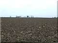
Where's The Path Gone
Ploughed field marked footpath gone looking west near to Mickfield, Suffolk.
Image: © Keith Evans
Taken: 6 Nov 2011
0.17 miles
2
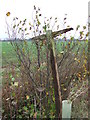
Rotten Footpath Sign
This rotten footpath sign had fallen down so like a good boy I helped other walkers by fixing it upright and in the correct direction the best I could. Near to Mickfield, Suffolk.
Image: © Keith Evans
Taken: 6 Nov 2011
0.20 miles