IMAGES TAKEN NEAR TO
Forward Green, STOWMARKET, IP14 5HF
Introduction
This page details the photographs taken nearby to IP14 5HF by members of the Geograph project.
The Geograph project started in 2005 with the aim of publishing, organising and preserving representative images for every square kilometre of Great Britain, Ireland and the Isle of Man.

There are currently over 7.5m images from over14,400 individuals and you can help contribute to the project by visiting https://www.geograph.org.uk
Image Map
Images are licensed for reuse under creativecommons.org/licenses/by-sa/2.0
Notes
- Clicking on the map will re-center to the selected point.
- The higher the marker number, the further away the image location is from the centre of the postcode.
Image Listing (9 Images Found)
Images are licensed for reuse under creativecommons.org/licenses/by-sa/2.0
Image
Details
Distance
1
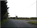
Main Road to Middlewood Green
At the junction with Mendlesham Green
Road No.C409
Image: © Geographer
Taken: 17 Oct 2014
0.02 miles
2
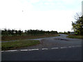
Mendlesham Green
At the junction with the Main Road to Middlewood Green
Image: © Geographer
Taken: 17 Oct 2014
0.02 miles
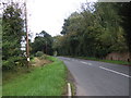
4
Minor road towards Middlewood Green
Heading south west.
Image: © JThomas
Taken: 15 Sep 2015
0.07 miles
7
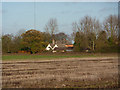
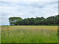
Moat Farm across the field
A view of the farm from the footpath near Middlewood Green. The large mast just east of the A140 near Mendlesham can be seen.
Image: © Andrew Hill
Taken: 15 Nov 2009
0.18 miles
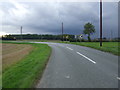
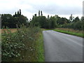
9
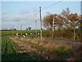
Road at Middlewood Green
This is part of quite a well used route between Stowupland and the A140. Seen from near the start of a footpath.
Image: © Andrew Hill
Taken: 15 Nov 2009
0.21 miles