IMAGES TAKEN NEAR TO
Mill Street, STOWMARKET, IP14 5BL
Introduction
This page details the photographs taken nearby to Mill Street, IP14 5BL by members of the Geograph project.
The Geograph project started in 2005 with the aim of publishing, organising and preserving representative images for every square kilometre of Great Britain, Ireland and the Isle of Man.

There are currently over 7.5m images from over14,400 individuals and you can help contribute to the project by visiting https://www.geograph.org.uk
Image Map
Images are licensed for reuse under creativecommons.org/licenses/by-sa/2.0
Notes
- Clicking on the map will re-center to the selected point.
- The higher the marker number, the further away the image location is from the centre of the postcode.
Image Listing (31 Images Found)
Images are licensed for reuse under creativecommons.org/licenses/by-sa/2.0
Image
Details
Distance
3
End of Mill Street
This road used to continue to Mill Street, Stowmarket before the A14 bisected it
Image: © Geographer
Taken: 26 Mar 2016
0.07 miles
5
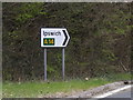
Roadsign on the A14 slip road
At the junction with Mill Street
Image: © Geographer
Taken: 26 Mar 2016
0.11 miles
6
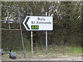
Roadsign on the A14 slip road
At the junction with Mill Street
Image: © Geographer
Taken: 26 Mar 2016
0.11 miles
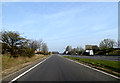
7
Approaching the A14
At the junction with Mill Street
Image: © Geographer
Taken: 29 Mar 2014
0.11 miles
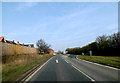
8

Mill Street, Stowmarket
At the junction with the A14 slip road
Image: © Geographer
Taken: 26 Mar 2016
0.11 miles
9
A14 slip Road, Stowupland
At the junction with Mill Street
Image: © Geographer
Taken: 26 Mar 2016
0.11 miles
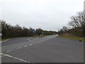
10
Approaching the A14
On the A14 Slip Road
Image: © Geographer
Taken: 29 Mar 2014
0.14 miles