IMAGES TAKEN NEAR TO
Goodrich Close, STOWMARKET, IP14 4RW
Introduction
This page details the photographs taken nearby to Goodrich Close, IP14 4RW by members of the Geograph project.
The Geograph project started in 2005 with the aim of publishing, organising and preserving representative images for every square kilometre of Great Britain, Ireland and the Isle of Man.

There are currently over 7.5m images from over14,400 individuals and you can help contribute to the project by visiting https://www.geograph.org.uk
Image Map
Images are licensed for reuse under creativecommons.org/licenses/by-sa/2.0
Notes
- Clicking on the map will re-center to the selected point.
- The higher the marker number, the further away the image location is from the centre of the postcode.
Image Listing (21 Images Found)
Images are licensed for reuse under creativecommons.org/licenses/by-sa/2.0
Image
Details
Distance
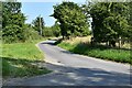
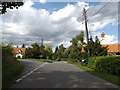
3
Church Road, Cotton
At the junction with Cock Road
Image: © Geographer
Taken: 12 Sep 2015
0.17 miles
4
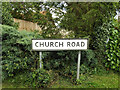
Church Road sign
On Church Road at the junction with Cock Road
Image: © Geographer
Taken: 12 Sep 2015
0.17 miles
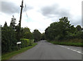
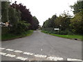
5
Church Road, Cotton
At the junction with Cock & Brookhouse roads
Image: © Geographer
Taken: 12 Sep 2015
0.18 miles
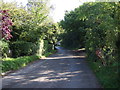
7
Scruffin's Lane, Cotton
At the junction with Mill Road
Image: © Geographer
Taken: 12 Sep 2015
0.19 miles
8
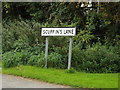
Scuffin's Lane sign
On Scuffin's Lane at the junction with Mill Road
Image: © Geographer
Taken: 12 Sep 2015
0.19 miles
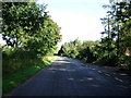
9
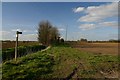
Footpath to Dandy Corner
North of the village of Cotton, this path leads towards the hamlet of Dandy Corner.
Image: © Bob Jones
Taken: 4 Apr 2007
0.21 miles
10
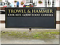
Trowell & Hammer Public House sign
Off Mill Road
http://www.trowelandhammercotton.com/
Image: © Geographer
Taken: 12 Sep 2015
0.22 miles