IMAGES TAKEN NEAR TO
Grapes Farmyard, STOWMARKET, IP14 4JY
Introduction
This page details the photographs taken nearby to Grapes Farmyard, IP14 4JY by members of the Geograph project.
The Geograph project started in 2005 with the aim of publishing, organising and preserving representative images for every square kilometre of Great Britain, Ireland and the Isle of Man.

There are currently over 7.5m images from over14,400 individuals and you can help contribute to the project by visiting https://www.geograph.org.uk
Image Map
Images are licensed for reuse under creativecommons.org/licenses/by-sa/2.0
Notes
- Clicking on the map will re-center to the selected point.
- The higher the marker number, the further away the image location is from the centre of the postcode.
Image Listing (85 Images Found)
Images are licensed for reuse under creativecommons.org/licenses/by-sa/2.0
Image
Details
Distance
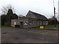
4
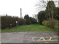
Finningham Lane bridleway to Ladywell Road
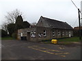
At Bacton Village Hall off Church Road
Image: © Geographer
Taken: 3 Apr 2015
0.04 miles
7
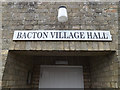
Bacton Village Hall sign
At Bacton Village Hall off Church Road
Image: © Geographer
Taken: 3 Apr 2015
0.04 miles
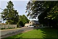
8
Church Road, Bacton
Near Bacton Village Hall
Image: © Geographer
Taken: 3 Apr 2015
0.05 miles
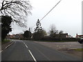
9
Pound Hill, Bacton
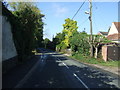
Looking west - the road shortly becomes Church Road.
Image: © JThomas
Taken: 17 Sep 2015
0.05 miles
10
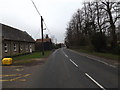
Church Road, Bacton
Near Bacton Village Hall
Image: © Geographer
Taken: 3 Apr 2015
0.05 miles