IMAGES TAKEN NEAR TO
Maple Road, STOWMARKET, IP14 4DH
Introduction
This page details the photographs taken nearby to Maple Road, IP14 4DH by members of the Geograph project.
The Geograph project started in 2005 with the aim of publishing, organising and preserving representative images for every square kilometre of Great Britain, Ireland and the Isle of Man.

There are currently over 7.5m images from over14,400 individuals and you can help contribute to the project by visiting https://www.geograph.org.uk
Image Map
Images are licensed for reuse under creativecommons.org/licenses/by-sa/2.0
Notes
- Clicking on the map will re-center to the selected point.
- The higher the marker number, the further away the image location is from the centre of the postcode.
Image Listing (57 Images Found)
Images are licensed for reuse under creativecommons.org/licenses/by-sa/2.0
Image
Details
Distance
1
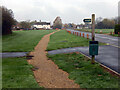
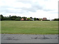
Thorney Green, Stowupland
Stowupland has a very extensive green, separated into different sections. The wooden posts are a relatively recent innovation to prevent vehicles straying from the road. The footpath leads through to Maple Road.
Image: © Stephen McKay
Taken: 13 Nov 2022
0.04 miles
3
Thorney Green, Stowupland
Off Thorney Green
Image: © Geographer
Taken: 30 Jul 2019
0.07 miles
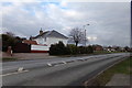
4
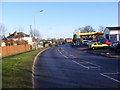
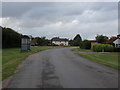
A1120 Church Road, Stowupland
Looking towards Stowupland
Image: © Geographer
Taken: 19 Dec 2008
0.09 miles
5
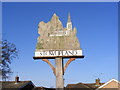
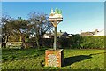
Stowupland Village Sign
On the A1120 church Road at the junction with the B1115
(close up)
Image: © Geographer
Taken: 19 Dec 2008
0.09 miles
6
Stowupland Village Sign
On the A1120 church Road at the junction with the B1115
Image: © Geographer
Taken: 19 Dec 2008
0.09 miles
7
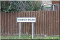
Church Road sign
On the A1120 Church Road
Image: © Geographer
Taken: 5 Feb 2018
0.09 miles
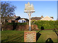
9
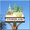
Stowupland village sign
This sign, made from a mould of the original replaces the old wooden one ( https://www.geograph.org.uk/photo/4294794 ). It shows the church and the trees in the churchyard. The brick over the ploughed soil represents the housing development on brown field sites.
Image: © Adrian S Pye
Taken: 20 Dec 2020
0.11 miles
10
Stowupland village sign
This sign, made from a mould of the original replaces the old wooden one ( https://www.geograph.org.uk/photo/4294794 ). It shows the church and the trees in the churchyard. The brick over the ploughed soil represents the housing development on brown field sites.
Image: © Adrian S Pye
Taken: 20 Dec 2020
0.11 miles