IMAGES TAKEN NEAR TO
Jubilee Crescent, STOWMARKET, IP14 4BT
Introduction
This page details the photographs taken nearby to Jubilee Crescent, IP14 4BT by members of the Geograph project.
The Geograph project started in 2005 with the aim of publishing, organising and preserving representative images for every square kilometre of Great Britain, Ireland and the Isle of Man.

There are currently over 7.5m images from over14,400 individuals and you can help contribute to the project by visiting https://www.geograph.org.uk
Image Map
Images are licensed for reuse under creativecommons.org/licenses/by-sa/2.0
Notes
- Clicking on the map will re-center to the selected point.
- The higher the marker number, the further away the image location is from the centre of the postcode.
Image Listing (66 Images Found)
Images are licensed for reuse under creativecommons.org/licenses/by-sa/2.0
Image
Details
Distance
1
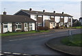
Reeds Way, Stowupland
Leading to quite a lot of recent housing development.
Image: © Andrew Hill
Taken: 14 Nov 2008
0.14 miles
2
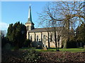
Holy Trinity Stowupland
Holy Trinity church Stowupland Suffolk for more info see http://www.suffolkchurches.co.uk/stowupland.html
Image: © Keith Evans
Taken: 1 Feb 2007
0.15 miles
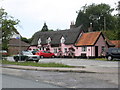
3
The Crown, Stowupland
According to the 1:25,000 map the pub is within the square.
Image: © Andrew Hill
Taken: 14 Nov 2008
0.15 miles
5
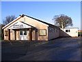
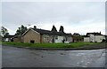
Stowupland Village Hall
Off the A1120 Church Road
Image: © Geographer
Taken: 19 Dec 2008
0.15 miles
6
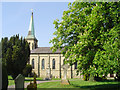
Stowupland Holy Trinity church
Stowupland church is Victorian, built in 1843 in white brick. It has an elegant copper-clad broached spire. In the churchyard at a bend in the path there is a memorial with an unusual illustration of a serpent wrapped round a shillelagh drinking from the fountain of life. The rather plain font was rescued from Creeting All Saints which until 1800 stood in the same churchyard as Creeting St Mary, about three miles away. Hanging at the west end is the painted cast iron Royal Arms of George IV. The woodwork of course is mostly Victorian and coeval with the church, but the 17th century pulpit is beautifully carved with scenes from the early life of Jesus, including his circumcision and presentation at the temple amongst others. It is of foreign origin, probably Flemish, so I was told.
Image: © Adrian S Pye
Taken: 28 Apr 2007
0.16 miles
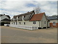
7
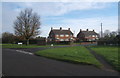
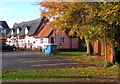
Gipping Road at the turn for Trinity Walk
Houses in Stowupland village.
Image: © Andrew Hill
Taken: 14 Nov 2008
0.16 miles
8
The Crown Public House, Stowupland
Off the A1120 Church Road
http://www.thecrownstowupland.co.uk/
Image: © Geographer
Taken: 25 Mar 2016
0.16 miles
10
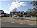
'The Crown' at Stowupland with a new look
Compare with http://www.geograph.org.uk/photo/2480461
http://www.geograph.org.uk/photo/5361806
Image: © Adrian S Pye
Taken: 23 Apr 2017
0.16 miles