IMAGES TAKEN NEAR TO
Church Road, STOWMARKET, IP14 4BG
Introduction
This page details the photographs taken nearby to Church Road, IP14 4BG by members of the Geograph project.
The Geograph project started in 2005 with the aim of publishing, organising and preserving representative images for every square kilometre of Great Britain, Ireland and the Isle of Man.

There are currently over 7.5m images from over14,400 individuals and you can help contribute to the project by visiting https://www.geograph.org.uk
Image Map
Images are licensed for reuse under creativecommons.org/licenses/by-sa/2.0
Notes
- Clicking on the map will re-center to the selected point.
- The higher the marker number, the further away the image location is from the centre of the postcode.
Image Listing (47 Images Found)
Images are licensed for reuse under creativecommons.org/licenses/by-sa/2.0
Image
Details
Distance
1
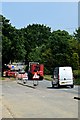
Roadworks on the A1120
Temporary traffic lights in Stowupland
Image: © John Myers
Taken: 29 May 2018
0.03 miles
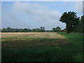
2
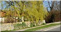
Weeping willow, Church Road, Stowupland
Image: © nick macneill
Taken: 26 Mar 2012
0.04 miles
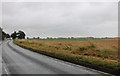
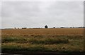
6
Stubble field and hedgerow beside Church Road
Looking west from Creeting Lane.
Image: © JThomas
Taken: 17 Sep 2015
0.09 miles
7

Oxlip Way sign
On Oxlip Way at the junction with the A1120 Church Road
Image: © Geographer
Taken: 22 Jul 2019
0.10 miles
8
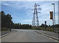
Oxlip Way, Stowupland
At the junction with the A1120 Church Road
Image: © Geographer
Taken: 22 Jul 2019
0.11 miles
9
Oxlip Way, Stowupland
At the junction with the A1120 Church Road
Image: © Geographer
Taken: 22 Jul 2019
0.11 miles
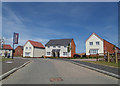
10
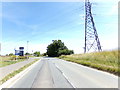
A1120 Church Road, Stowupland
At the junction with Oxlip Way
Image: © Geographer
Taken: 22 Jul 2019
0.11 miles