IMAGES TAKEN NEAR TO
Apple Grove, STOWMARKET, IP14 3RB
Introduction
This page details the photographs taken nearby to Apple Grove, IP14 3RB by members of the Geograph project.
The Geograph project started in 2005 with the aim of publishing, organising and preserving representative images for every square kilometre of Great Britain, Ireland and the Isle of Man.

There are currently over 7.5m images from over14,400 individuals and you can help contribute to the project by visiting https://www.geograph.org.uk
Image Map
Images are licensed for reuse under creativecommons.org/licenses/by-sa/2.0
Notes
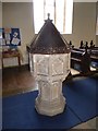
- Clicking on the map will re-center to the selected point.
- The higher the marker number, the further away the image location is from the centre of the postcode.
Image Listing (107 Images Found)
Images are licensed for reuse under creativecommons.org/licenses/by-sa/2.0
Image
Details
Distance
1
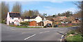
North side of Wetherden village seen from Church Street
Keep right for the lanes to Bacton and Haughley. The left turn (Ashfield Road) leads to minor country lanes in the direction of Badwell Ash and Walsham-le-Willows.
Image: © Andrew Hill
Taken: 30 Mar 2008
0.07 miles
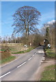
4
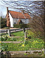
Springtime in Wetherden churchyard, looking across Church Street
Image: © Andrew Hill
Taken: 30 Mar 2008
0.11 miles
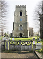
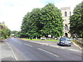
6
St Mary the Virgin, Wetherden - East end
Image: © John Salmon
Taken: 8 Apr 2019
0.13 miles
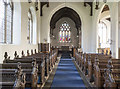
7
St Mary the Virgin, Wetherden - South arcade
Image: © John Salmon
Taken: 8 Apr 2019
0.13 miles
8

St Mary the Virgin, Wetherden - Stained glass window
Image: © John Salmon
Taken: 8 Apr 2019
0.13 miles
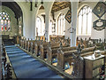
9
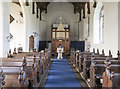
St Mary the Virgin, Wetherden - West end
Image: © John Salmon
Taken: 8 Apr 2019
0.13 miles