IMAGES TAKEN NEAR TO
Dagworth Lane, STOWMARKET, IP14 3QJ
Introduction
This page details the photographs taken nearby to Dagworth Lane, IP14 3QJ by members of the Geograph project.
The Geograph project started in 2005 with the aim of publishing, organising and preserving representative images for every square kilometre of Great Britain, Ireland and the Isle of Man.

There are currently over 7.5m images from over14,400 individuals and you can help contribute to the project by visiting https://www.geograph.org.uk
Image Map
Images are licensed for reuse under creativecommons.org/licenses/by-sa/2.0
Notes
- Clicking on the map will re-center to the selected point.
- The higher the marker number, the further away the image location is from the centre of the postcode.
Image Listing (11 Images Found)
Images are licensed for reuse under creativecommons.org/licenses/by-sa/2.0
Image
Details
Distance
2
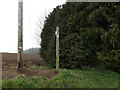
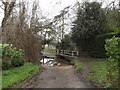
Footpath to Fishponds Way
Off Dagworth Lane
Image: © Geographer
Taken: 3 Apr 2015
0.05 miles
3
Field path towards Dagworth Lane
Cutting off a corner when walking from Haughley.
Image: © Andrew Hill
Taken: 16 Oct 2008
0.11 miles
4
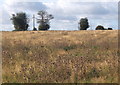
Field between Dagworth and Haughley
Plenty of thistles here, a good home for Eeyore maybe?
Image: © Andrew Hill
Taken: 16 Oct 2008
0.14 miles
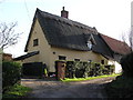
5
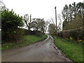
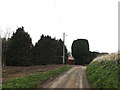
Dagworth Lane, Dagworth
Looking towards Fishponds Way
Image: © Geographer
Taken: 3 Apr 2015
0.17 miles
6
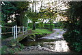
Ford at Dagworth Hall, Haughley
This ford is found at a cul-de-sac to Dagworth.
Image: © John Walton
Taken: 7 Nov 2012
0.18 miles
7
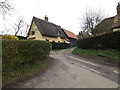
Dagworth Lane, Dagworth
Looking towards Hop Farm
Image: © Geographer
Taken: 3 Apr 2015
0.18 miles
10
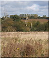
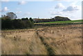
Fields and trees southeast of Haughley
On a short footpath cutting off a bit of a corner from Dagworth.
Image: © Andrew Hill
Taken: 16 Oct 2008
0.20 miles