IMAGES TAKEN NEAR TO
Haughley, STOWMARKET, IP14 3NP
Introduction
This page details the photographs taken nearby to IP14 3NP by members of the Geograph project.
The Geograph project started in 2005 with the aim of publishing, organising and preserving representative images for every square kilometre of Great Britain, Ireland and the Isle of Man.

There are currently over 7.5m images from over14,400 individuals and you can help contribute to the project by visiting https://www.geograph.org.uk
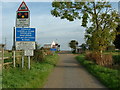
Image Map
Images are licensed for reuse under creativecommons.org/licenses/by-sa/2.0
Notes
- Clicking on the map will re-center to the selected point.
- The higher the marker number, the further away the image location is from the centre of the postcode.
Image Listing (9 Images Found)
Images are licensed for reuse under creativecommons.org/licenses/by-sa/2.0
Image
Details
Distance
2
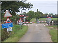
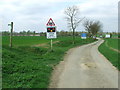
Across the Tracks
Level crossing at the end of Wassicks Lane near to Ward Green Suffolk.
Image: © Keith Evans
Taken: 5 Nov 2006
0.16 miles
3
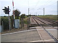
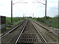
Looking up the Norwich line through Suffolk
Image: © Andrew Hill
Taken: 6 Oct 2007
0.17 miles
6
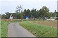
Approaching The Crossing
Approaching the level crossing on Wassicks Lane near to Ward Green, Suffolk.
Image: © Keith Evans
Taken: 7 Apr 2011
0.21 miles
7
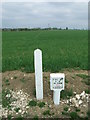
Pipeline Crossing
Marker marking the point of a pipeline crossing Wassicks Lane near to Ward Green, Suffolk.
Image: © Keith Evans
Taken: 7 Apr 2011
0.22 miles
8
London To Norwich
Looking in the direction of London on the London to Norwich railway line near to Ward Green, Suffolk.
Image: © Keith Evans
Taken: 7 Apr 2011
0.22 miles
9
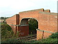
Railway Footbridge
Footbridge across the London to Norwich railway line near to Wards Green Suffolk.
Image: © Keith Evans
Taken: 5 Nov 2006
0.23 miles