IMAGES TAKEN NEAR TO
The Green, STOWMARKET, IP14 3JE
Introduction
This page details the photographs taken nearby to The Green, IP14 3JE by members of the Geograph project.
The Geograph project started in 2005 with the aim of publishing, organising and preserving representative images for every square kilometre of Great Britain, Ireland and the Isle of Man.

There are currently over 7.5m images from over14,400 individuals and you can help contribute to the project by visiting https://www.geograph.org.uk
Image Map
Images are licensed for reuse under creativecommons.org/licenses/by-sa/2.0
Notes
- Clicking on the map will re-center to the selected point.
- The higher the marker number, the further away the image location is from the centre of the postcode.
Image Listing (40 Images Found)
Images are licensed for reuse under creativecommons.org/licenses/by-sa/2.0
Image
Details
Distance
1
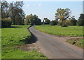
Houses at Shelland
Although there is a church, Shelland is scarcely large enough to be a hamlet - there are apparently nine listed on the current eloctoral roll. http://www.suffolkchurches.co.uk
Image: © Andrew Hill
Taken: 9 Oct 2008
0.04 miles
2
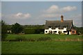
Cottage at Shelland
According to the electoral roll, only nine people live in the tiny hamlet of Shelland, east of Woolpit.
Image: © Bob Jones
Taken: 23 Sep 2006
0.04 miles
3
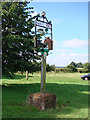
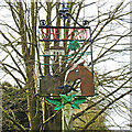
Shelland village sign
Shelland village sign, sited on the village green, is surmounted by a crown representing the church of King Charles the Martyr which itself is depicted next to a tree. Also depicted are cow, horse and sheep, representing the livestock farming, flanked on either side by some ears of wheat, and below a sugar beet.
It was erected to celebrate the millennium in 2000. https://www.geograph.org.uk/photo/6779713
Image: © Adrian S Pye
Taken: 26 Aug 2007
0.04 miles
6
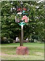
Shelland village sign
Shelland village sign, sited on the village green, is surmounted by a crown representing the church of King Charles the Martyr which is itself depicted next to a tree. Also depicted are cow, horse and sheep, representing the livestock farming flanked on either side by some ears of wheat, and below a sugar beet. It was erected to celebrate the millennium in 2000. https://www.geograph.org.uk/photo/4294752
Image: © Adrian S Pye
Taken: 14 Mar 2021
0.05 miles
8
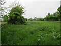
Lane crossing open ground west of Shelland
Heading towards Woolpit.
Image: © Andrew Hill
Taken: 9 Oct 2008
0.07 miles
9
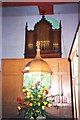
Organ and font at Shelland
Inside the church of King Charles the Martyr, built in 1767. The barrel organ, installed in 1820, is the only one remaining in Suffolk. There are Easter flowers before the 18th-century octagonal font, with its classical cover and "big, coarse leaf" decoration noted by Pevsner. For more on this church see http://www.suffolkchurches.co.uk/shelland.html
Image: © Tiger
Taken: 1 Apr 1991
0.08 miles
10
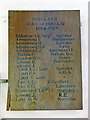
Roll of Honour in Shelland church
The Roll of Honour in Shelland church of King Charles the Martyr bears 17 names of the men who fought in the Great War and returned home.
The War Memorial which is located close by can be seen here > https://www.geograph.org.uk/photo/6574452
Image: © Adrian S Pye
Taken: 30 May 2015
0.08 miles