IMAGES TAKEN NEAR TO
The Green, STOWMARKET, IP14 3HT
Introduction
This page details the photographs taken nearby to The Green, IP14 3HT by members of the Geograph project.
The Geograph project started in 2005 with the aim of publishing, organising and preserving representative images for every square kilometre of Great Britain, Ireland and the Isle of Man.

There are currently over 7.5m images from over14,400 individuals and you can help contribute to the project by visiting https://www.geograph.org.uk
Image Map
Images are licensed for reuse under creativecommons.org/licenses/by-sa/2.0
Notes
- Clicking on the map will re-center to the selected point.
- The higher the marker number, the further away the image location is from the centre of the postcode.
Image Listing (33 Images Found)
Images are licensed for reuse under creativecommons.org/licenses/by-sa/2.0
Image
Details
Distance
2

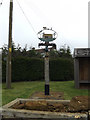
Harleston Village sign
Off Cutler's Lane at the junction with Haughley and Forest Roads
(Close up)
Image: © Geographer
Taken: 3 Apr 2015
0.05 miles
3
Harleston Village sign
Off Cutler's Lane at the junction with Haughley and Forest Roads
Image: © Geographer
Taken: 3 Apr 2015
0.05 miles
4
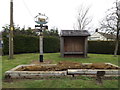
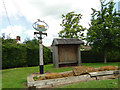
Harleston Village sign & Bus Shelter
Off Cutler's Lane at the junction with Haughley and Forest Roads
Image: © Geographer
Taken: 3 Apr 2015
0.05 miles
5
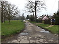
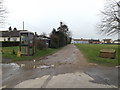
Village scene, Harleston
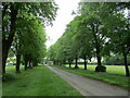
This corner marks the end of Forest Road, with Haughley Road curving right. There is a left turn for Cutlers Lane.
Image: © Andrew Hill
Taken: 9 Oct 2008
0.05 miles
6
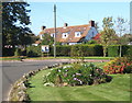
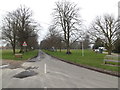
Footpath off Cutler's Lane
At the junction with Haughley and Forest Roads
Image: © Geographer
Taken: 3 Apr 2015
0.05 miles
7
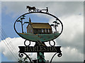
Harleston village sign (detail)
The sign for the small village of Harleston is surmounted by a ploughing scene. Below in the oval wrought sign is an image of the church of St Augustine set in the churchyard surroundings almost as it is in reality. Immediately below are some ears of wheat representing the agricultural heritage of the parish, flanked by two horseshoes as a reminder of the local farrier and the importance of the horse. Within the supports are an anvil and hammer representing the local blacksmith on one side, and on the other milk churns representing the dairy farmers in the parish. Between them in the centre are leaves of a lime tree which relate to the avenue on the common either side of Cutler’s Lane.
https://www.geograph.org.uk/photo/4500338
Image: © Adrian S Pye
Taken: 30 May 2015
0.05 miles
8
Village sign and shelter at Harleston
The sign for the small village of Harleston is surmounted by a ploughing scene. Below in the oval wrought sign is an image of the church of St Augustine set in the churchyard surroundings almost as it is in reality. Immediately below are some ears of wheat representing the agricultural heritage of the parish, flanked by two horseshoes as a reminder of the local farrier and the importance of the horse. Within the supports are an anvil and hammer representing the local blacksmith on one side, and on the other milk churns representing the dairy farmers in the parish. Between them in the centre are leaves of a lime tree which relate to the avenue on the common either side of Cutler’s Lane.
https://www.geograph.org.uk/photo/4500342
Image: © Adrian S Pye
Taken: 30 May 2015
0.05 miles
9
Cutlers Lane, Harleston
At the junction with Haughley and Forest Roads
Image: © Geographer
Taken: 3 Apr 2015
0.05 miles
10
Track off Cutler's Lane
At the junction with Haughley and Forest Roads
Image: © Geographer
Taken: 3 Apr 2015
0.05 miles