IMAGES TAKEN NEAR TO
Valley Lane, STOWMARKET, IP14 3BD
Introduction
This page details the photographs taken nearby to Valley Lane, IP14 3BD by members of the Geograph project.
The Geograph project started in 2005 with the aim of publishing, organising and preserving representative images for every square kilometre of Great Britain, Ireland and the Isle of Man.

There are currently over 7.5m images from over14,400 individuals and you can help contribute to the project by visiting https://www.geograph.org.uk
Image Map
Images are licensed for reuse under creativecommons.org/licenses/by-sa/2.0
Notes
- Clicking on the map will re-center to the selected point.
- The higher the marker number, the further away the image location is from the centre of the postcode.
Image Listing (7 Images Found)
Images are licensed for reuse under creativecommons.org/licenses/by-sa/2.0
Image
Details
Distance
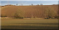
1
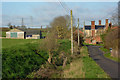
Valley Farm
Looking down on the roofs of Valley Farm Buildings.
Image: © Dave King
Taken: 1 Jan 2007
0.01 miles
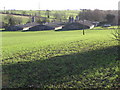
3
Valley Farm
Seen from Valley lane south of Great Finborough.
Image: © Andrew Hill
Taken: 14 Feb 2009
0.06 miles
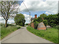
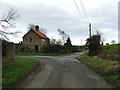
4
Valley Lane
Looking along Valley Lane to the corner of Jacks Lane to the right.
Image: © Andrew Hill
Taken: 10 Dec 2009
0.07 miles
5
Road Junction
Road junction of Valley Lane and Jack's Lane near to Great Finborough, Suffolk.
Image: © Keith Evans
Taken: 16 Jan 2011
0.08 miles
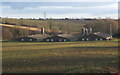
6
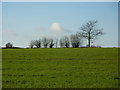
Field by Valley Lane
The field slopes gently up to the west of the lane.
Image: © Andrew Hill
Taken: 10 Dec 2009
0.18 miles