IMAGES TAKEN NEAR TO
Burnt House Lane, STOWMARKET, IP14 2ND
Introduction
This page details the photographs taken nearby to Burnt House Lane, IP14 2ND by members of the Geograph project.
The Geograph project started in 2005 with the aim of publishing, organising and preserving representative images for every square kilometre of Great Britain, Ireland and the Isle of Man.

There are currently over 7.5m images from over14,400 individuals and you can help contribute to the project by visiting https://www.geograph.org.uk
Image Map
Images are licensed for reuse under creativecommons.org/licenses/by-sa/2.0
Notes
- Clicking on the map will re-center to the selected point.
- The higher the marker number, the further away the image location is from the centre of the postcode.
Image Listing (10 Images Found)
Images are licensed for reuse under creativecommons.org/licenses/by-sa/2.0
Image
Details
Distance
1
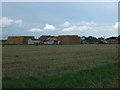
Stubble field, Battisford Tye
North of Battisford Straight.
Image: © JThomas
Taken: 14 Sep 2015
0.08 miles
2
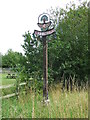
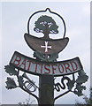
Battisford village sign
The sign is surmounted by an oak tree and the cross below represents the hospital of knights of St. John of Jerusalem was erected here in the reign of Henry II. The trumpet and serpent are instruments once used in the musicians gallery of the church instead of the traditional organ and now reside in the Christchurch Mansion Museum in Ipswich.
Image: © Adrian S Pye
Taken: 20 Dec 2020
0.11 miles
3
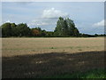
Straight Road
Heading east from Battisford Tye.
Image: © JThomas
Taken: 14 Sep 2015
0.11 miles
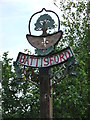
4
Village Sign
Village Sign
Battisford village sign Battisford Tye, Suffolk. For close up view see http://www.geograph.org.uk/photo/2565522
Image: © Keith Evans
Taken: 21 Aug 2011
0.12 miles
5
Village Sign
Battisford village sign Battisford Tye, Suffolk. For overall view see http://www.geograph.org.uk/photo/2565531
Image: © Keith Evans
Taken: 21 Aug 2011
0.13 miles
6
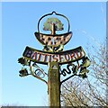
Battisford village sign
The sign is surmounted by an oak tree and the cross below represents the hospital of knights of St. John of Jerusalem was erected here in the reign of Henry II. The trumpet and serpent are instruments once used in the musicians gallery of the church instead of the traditional organ and now reside in the Christchurch Mansion Museum in Ipswich.
Image: © Adrian S Pye
Taken: 20 Dec 2020
0.13 miles
7
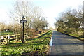
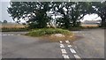
Road Junction
Road junction of Burnhouse Lane and Battisford Straight guess which is which near to Battisford Tye, Suffolk.
Image: © Keith Evans
Taken: 21 Aug 2011
0.17 miles
8
Battisford village sign
I was intrigued by the snake depicted lower right. In fact it represents a musical instrument called a serpent. According to the excellent http://www.suffolkchurches.co.uk site, Battisford church (some distance away in Image) and nearby Barking were the home of two examples of this unusual instrument to be found in Suffolk.
Image: © Andrew Hill
Taken: 8 Sep 2007
0.19 miles
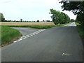
9
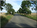
Road junction and grass triangle
Small road junction on the Battisford Straight.
Image: © Michael Trolove
Taken: 10 Sep 2017
0.21 miles