IMAGES TAKEN NEAR TO
Water Vole Close, STOWMARKET, IP14 2FB
Introduction
This page details the photographs taken nearby to Water Vole Close, IP14 2FB by members of the Geograph project.
The Geograph project started in 2005 with the aim of publishing, organising and preserving representative images for every square kilometre of Great Britain, Ireland and the Isle of Man.

There are currently over 7.5m images from over14,400 individuals and you can help contribute to the project by visiting https://www.geograph.org.uk
Image Map
Images are licensed for reuse under creativecommons.org/licenses/by-sa/2.0
Notes
- Clicking on the map will re-center to the selected point.
- The higher the marker number, the further away the image location is from the centre of the postcode.
Image Listing (24 Images Found)
Images are licensed for reuse under creativecommons.org/licenses/by-sa/2.0
Image
Details
Distance
1

Cut Mark Stowmarket No 145 Lime Tree Place
Cut Mark Stowmarket No 145 Lime Tree Place SW face, S angle.
Image: © Cud05
Taken: 31 Mar 2018
0.08 miles
2
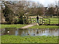
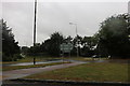
Park area with flooding
Ducks enjoying a temporary pool in the park in the angle between Needham Road and Ipswich Road.
Image: © Andrew Hill
Taken: 2 Mar 2010
0.12 miles
3
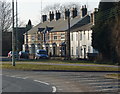
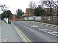
Houses near the Combs Ford roundabout
Looking across the end of Gipping Way to houses on Needham Road.
Image: © Andrew Hill
Taken: 17 Feb 2010
0.13 miles
4
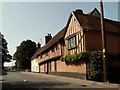
Old house at Stowmarket, Suffolk
This old timber-framed house stands on part of the original main road from Needham Market.
Image: © Robert Edwards
Taken: 6 Sep 2006
0.14 miles
5
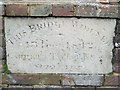
Bridge Widening
Stone tablet in bridge wall at Stowmarket, Suffolk see http://www.geograph.org.uk/photo/2252920 for overall view.
Image: © Keith Evans
Taken: 30 Jan 2011
0.14 miles
6
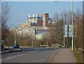
Gipping Way and Stowmarket industry
Looking along the road towards factories in the next square. The largest buildings in the background are those of ICI paints.
Image: © Andrew Hill
Taken: 17 Feb 2010
0.14 miles
7
Bridge On Ipswich Road
Bridge on Ipswich Road Stowmarket, Suffolk. This road was the A.45 later renumbered A.14 till it bypassed Stowmarket in the late 1970s. The stone tablet in the wall records the widening of the bridge in 1842 see http://www.geograph.org.uk/photo/2252923
Image: © Keith Evans
Taken: 30 Jan 2011
0.15 miles
9
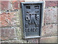
Ordnance Survey Flush Bracket S8199
This can be found on a house wall in Ipswich Road, Stowmarket.
For more detail see : http://www.bench-marks.org.uk/bm13946
Image: © Peter Wood
Taken: 14 Nov 2014
0.16 miles
10
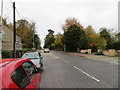
Ipswich Road, Stowmarket
Looking northward towards the Town Centre.
Image: © Peter Wood
Taken: 14 Nov 2014
0.16 miles