IMAGES TAKEN NEAR TO
Moats Tye, STOWMARKET, IP14 2EZ
Introduction
This page details the photographs taken nearby to Moats Tye, IP14 2EZ by members of the Geograph project.
The Geograph project started in 2005 with the aim of publishing, organising and preserving representative images for every square kilometre of Great Britain, Ireland and the Isle of Man.

There are currently over 7.5m images from over14,400 individuals and you can help contribute to the project by visiting https://www.geograph.org.uk
Image Map
Images are licensed for reuse under creativecommons.org/licenses/by-sa/2.0
Notes
- Clicking on the map will re-center to the selected point.
- The higher the marker number, the further away the image location is from the centre of the postcode.
Image Listing (14 Images Found)
Images are licensed for reuse under creativecommons.org/licenses/by-sa/2.0
Image
Details
Distance
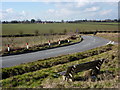
2
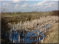
Laneside pond at Moats Tye
With reed stalks covering a large part of the surface.
Image: © Andrew Hill
Taken: 2 Mar 2010
0.05 miles
3
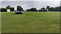
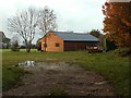
Battisford Cricket Ground
A well maintained cricket ground.
Image: © Michael Trolove
Taken: 10 Sep 2017
0.06 miles
4
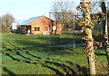
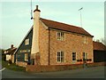
Battisford cricket club, located at Moats Tye
Image: © Andrew Hill
Taken: 16 Nov 2007
0.07 miles
7

Field, trees and old chimney stack
A ruined building at Moats Tye north of Battisford.
Image: © Andrew Hill
Taken: 2 Mar 2010
0.17 miles
8
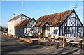
'The Carpenters Arms' inn at Moats Tye
Image: © Robert Edwards
Taken: 15 Nov 2006
0.17 miles
10
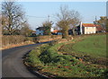
Bench by the lane to Combs
Near a lane junction at Moats Tye with open views.
Image: © Andrew Hill
Taken: 2 Mar 2010
0.18 miles