IMAGES TAKEN NEAR TO
Moats Tye, STOWMARKET, IP14 2EX
Introduction
This page details the photographs taken nearby to Moats Tye, IP14 2EX by members of the Geograph project.
The Geograph project started in 2005 with the aim of publishing, organising and preserving representative images for every square kilometre of Great Britain, Ireland and the Isle of Man.

There are currently over 7.5m images from over14,400 individuals and you can help contribute to the project by visiting https://www.geograph.org.uk
Image Map
Images are licensed for reuse under creativecommons.org/licenses/by-sa/2.0
Notes
- Clicking on the map will re-center to the selected point.
- The higher the marker number, the further away the image location is from the centre of the postcode.
Image Listing (5 Images Found)
Images are licensed for reuse under creativecommons.org/licenses/by-sa/2.0
Image
Details
Distance
2
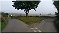
Road junction and grass triangle
Action picture with a local cyclist pedalling by.
Image: © Michael Trolove
Taken: 10 Sep 2017
0.04 miles
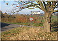
4
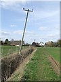
The Leaning Pole Of Moats Tyre
Leaning pole near to Moats Tyre, Suffolk.
Image: © Keith Evans
Taken: 21 Mar 2010
0.10 miles