IMAGES TAKEN NEAR TO
Hoxne Close, STOWMARKET, IP14 2BS
Introduction
This page details the photographs taken nearby to Hoxne Close, IP14 2BS by members of the Geograph project.
The Geograph project started in 2005 with the aim of publishing, organising and preserving representative images for every square kilometre of Great Britain, Ireland and the Isle of Man.

There are currently over 7.5m images from over14,400 individuals and you can help contribute to the project by visiting https://www.geograph.org.uk
Image Map
Images are licensed for reuse under creativecommons.org/licenses/by-sa/2.0
Notes
- Clicking on the map will re-center to the selected point.
- The higher the marker number, the further away the image location is from the centre of the postcode.
Image Listing (7 Images Found)
Images are licensed for reuse under creativecommons.org/licenses/by-sa/2.0
Image
Details
Distance
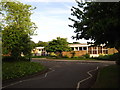
2
Lindsey Way approaching junction with Lavenham Way
Image: © Andrew Hill
Taken: 8 Oct 2008
0.13 miles
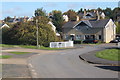
3
Lindsey Way
A residential street in Combs Ford just south of Stowmarket.
Image: © Andrew Hill
Taken: 8 Oct 2008
0.16 miles
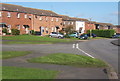
5

Combs: The approach to St. Mary's Church and part of the churchyard
Image: © Michael Garlick
Taken: 16 Feb 2019
0.24 miles
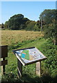
7
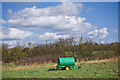
Farm equipment at Church Meadow nature reserve
Farm equipment sitting in a field on the south east side of Church Meadow nature reserve.
Image: © Adam Lack
Taken: 21 Mar 2017
0.24 miles