IMAGES TAKEN NEAR TO
Amis Close, STOWMARKET, IP14 1XE
Introduction
This page details the photographs taken nearby to Amis Close, IP14 1XE by members of the Geograph project.
The Geograph project started in 2005 with the aim of publishing, organising and preserving representative images for every square kilometre of Great Britain, Ireland and the Isle of Man.

There are currently over 7.5m images from over14,400 individuals and you can help contribute to the project by visiting https://www.geograph.org.uk
Image Map
Images are licensed for reuse under creativecommons.org/licenses/by-sa/2.0
Notes
- Clicking on the map will re-center to the selected point.
- The higher the marker number, the further away the image location is from the centre of the postcode.
Image Listing (4 Images Found)
Images are licensed for reuse under creativecommons.org/licenses/by-sa/2.0
Image
Details
Distance
1
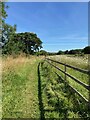
Bridleway near the balancing ponds
For a view of the balancing ponds (storm water lagoons) see Image
Image: © Chris Holifield
Taken: 8 Aug 2024
0.14 miles
2
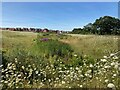
Balancing ponds or storm drain lagoons
These features have been created as storm water lagoons. At the time of the photograph they appeared to be empty and covered in wild flowers
Image: © Chris Holifield
Taken: 8 Aug 2024
0.16 miles
4
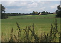
Open fields near Chilton Leys
Shepherd's Farm, named on 1:25,000 map, in the distance (at the northern edge of the next square east)
Image: © Andrew Hill
Taken: 10 Sep 2008
0.25 miles