IMAGES TAKEN NEAR TO
Iliffe Way, STOWMARKET, IP14 1SL
Introduction
This page details the photographs taken nearby to Iliffe Way, IP14 1SL by members of the Geograph project.
The Geograph project started in 2005 with the aim of publishing, organising and preserving representative images for every square kilometre of Great Britain, Ireland and the Isle of Man.

There are currently over 7.5m images from over14,400 individuals and you can help contribute to the project by visiting https://www.geograph.org.uk
Image Map
Images are licensed for reuse under creativecommons.org/licenses/by-sa/2.0
Notes
- Clicking on the map will re-center to the selected point.
- The higher the marker number, the further away the image location is from the centre of the postcode.
Image Listing (256 Images Found)
Images are licensed for reuse under creativecommons.org/licenses/by-sa/2.0
Image
Details
Distance
1
Edgar's Farmhouse
Edgar’s House was found in the village of Combs, a short distance south of here. The 14th century building has been built into a Victorian farmhouse. In 1970 it was saved from demolition, becoming the first of many relocation buildings on this site.
The first records show John Adgor and his wife Ascelina as owners. In 1346 the Adgors had nearly 40 acres of arable land, 1.5 acres of meadow, 1 acre of pasture, a rood of wood and 3 acres of alderwood in their books. In return for this an annual rent of 12 shillings was paid along with the task every three weeks of enforcing the law in the courts.
Evidence suggests that the family survived the deadly Black Death (1348-50), shortly after building this farmhouse.
The building is now listed and restored to its original state; however, the tiled roof was kept.
See Image'>Image and Image]
Image: © Ashley Dace
Taken: 9 Sep 2010
0.03 miles
2
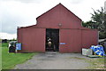
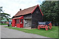
The Mortlock Building
Constructed by Deacons builders in 1918 after the First World War, the clients being Frank Mortlock & Sons of Lavenham. The Mortlocks (a father and two sons) were agricultural engineers and this became the workshop. Repairing engines, ploughs and anything agriculture. The site was in this use until the 1960s, by 1993 BP decided to sell the land for housing. Several grants saw the relocation here, erection taking place in the winter of 2004/2005.
Image: © Ashley Dace
Taken: 9 Sep 2010
0.03 miles
3
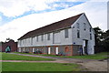
The Boby Building
This factory building was saved from demolition in the 1970s when the factory closed. A photographical survey was carried out and the timbers numbered. The mix of East Anglian styles being the major reason for saving this building. It was reerected in 1984 and now houses many industrial exhibits. Including steam engines, diesel engines and products of the firm, which lasted from 1843 until the 1970s. The Mortlock building can be seen behind Image
Image: © Ashley Dace
Taken: 9 Sep 2010
0.03 miles
4
Edgar's Farmhouse
Edgar’s House was found in the village of Combs, a short distance south of here. The 14th century building has been built into a Victorian farmhouse. In 1970 it was saved from demolition, becoming the first of many relocation buildings on this site.
The first records show John Adgor and his wife Ascelina as owners. In 1346 the Adgors had nearly 40 acres of arable land, 1.5 acres of meadow, 1 acre of pasture, a rood of wood and 3 acres of alderwood in their books. In return for this an annual rent of 12 shillings was paid along with the task every three weeks of enforcing the law in the courts.
Evidence suggests that the family survived the deadly Black Death (1348-50), shortly after building this farmhouse.
The building is now listed and restored to its original state; however, the tiled roof was kept.
See Image] and Image]
Image: © Ashley Dace
Taken: 9 Sep 2010
0.03 miles
5

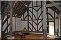
Edgar's Farmhouse
The roof gap allowing smoke to escape, the decorated timbers can also be seen. Thankfully a massive bonfire was avoided and the building saved.
See Image]
Image: © Ashley Dace
Taken: 9 Sep 2010
0.03 miles
6
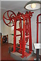
Boby Improved Double Barrel Pump
Robert Boby was a major manufacturer in the town of Bury St Edmunds from 1843 until the 1970s. This is one of their pumps they produced, driven off a belt.
Image: © Ashley Dace
Taken: 9 Sep 2010
0.04 miles
7

Stowmarket, Food Museum: A large number of daffodils
Image: © Michael Garlick
Taken: 11 Mar 2023
0.05 miles
8
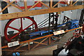
Horizontal Engine in the Boby Building
This view shows the entire engine, the condenser unit is the blue unit to the right.
See Image]
Image: © Ashley Dace
Taken: 9 Sep 2010
0.05 miles
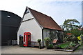
10
Grundisburgh Forge
Almost every village in East Anglia had a small forge, a few examples off the top of my head being Seething and Loddon (sadly demolished). This example was built around 1750; for nearly two hundred years this smithy was a busy, hot and noisy place. Many metal items could be made here, repairs also.
The last owner, a Frederick Joseph Crapnell, took the business in 1913 from his father. Amazingly in 1968 he retired, at the age of 86!
The building was saved from demolition and re-erected at the museum of East Anglian Rural Life in the early 1970s.
Image: © Ashley Dace
Taken: 9 Sep 2010
0.06 miles