IMAGES TAKEN NEAR TO
Henley Road, IPSWICH, IP1 3SD
Introduction
This page details the photographs taken nearby to Henley Road, IP1 3SD by members of the Geograph project.
The Geograph project started in 2005 with the aim of publishing, organising and preserving representative images for every square kilometre of Great Britain, Ireland and the Isle of Man.

There are currently over 7.5m images from over14,400 individuals and you can help contribute to the project by visiting https://www.geograph.org.uk
Image Map
Images are licensed for reuse under creativecommons.org/licenses/by-sa/2.0
Notes
- Clicking on the map will re-center to the selected point.
- The higher the marker number, the further away the image location is from the centre of the postcode.
Image Listing (51 Images Found)
Images are licensed for reuse under creativecommons.org/licenses/by-sa/2.0
Image
Details
Distance
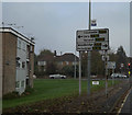
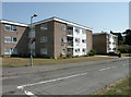
2
Henley Road, Castle Hill, Ipswich
At the junction with the A1214 Valley Road
Image: © Geographer
Taken: 2 Nov 2015
0.03 miles
4
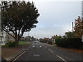
Henley Road, Castle Hill, Ipswich
Approaching the A1214 Valley Road
Image: © Geographer
Taken: 2 Nov 2015
0.03 miles
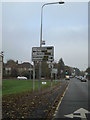
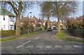
6
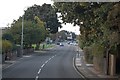
Henley Road Junction
A view north along Henley Road to its junction with the A1214 ring road. Beyond the traffic lights Henley Road continues on to the village of Henley.
Image: © Trevor Harris
Taken: 28 Sep 2008
0.03 miles
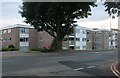
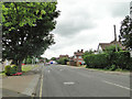
8
Houses on Henley Road
Looking past the junction with Woodstone Avenue.
Image: © Andrew Hill
Taken: 3 Apr 2009
0.06 miles
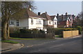
10
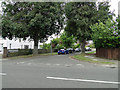
Woodstone Avenue from Henley Road, Ipswich
Image: © Adrian S Pye
Taken: 23 Jun 2015
0.07 miles