IMAGES TAKEN NEAR TO
Ivry Street, IPSWICH, IP1 3QW
Introduction
This page details the photographs taken nearby to Ivry Street, IP1 3QW by members of the Geograph project.
The Geograph project started in 2005 with the aim of publishing, organising and preserving representative images for every square kilometre of Great Britain, Ireland and the Isle of Man.

There are currently over 7.5m images from over14,400 individuals and you can help contribute to the project by visiting https://www.geograph.org.uk
Image Map
Images are licensed for reuse under creativecommons.org/licenses/by-sa/2.0
Notes
- Clicking on the map will re-center to the selected point.
- The higher the marker number, the further away the image location is from the centre of the postcode.
Image Listing (87 Images Found)
Images are licensed for reuse under creativecommons.org/licenses/by-sa/2.0
Image
Details
Distance
1
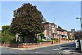
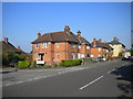
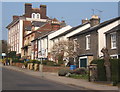
Victorian villas on Ivry Street
Looking north-east from the junction with Warrington Road.
Image: © Simon Mortimer
Taken: 12 Sep 2020
0.05 miles
2
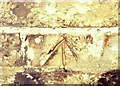
Cut Mark Ipswich Newson Street Junction
Cut Mark Ipswich Newson Street Junction, unverified.
Image: © Cud05
Taken: 13 Apr 2016
0.07 miles
3
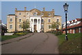
Anglesea Heights nursing home
The home overlooks the length of the High Street heading down towards the centre of Ipswich.
Image: © Andrew Hill
Taken: 3 Apr 2009
0.07 miles
4
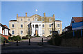
Anglesea Heights Residential and Nursing Home
This BUPA nursing home was once the main hospital for the town of Ipswich. http://www.bupacarehomes.co.uk/carehomes/asp/index.asp?ch=AngleseaHeightsNursingHome
Image: © Bob Jones
Taken: 4 Nov 2009
0.07 miles
5
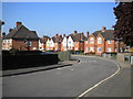
Housing on Anglesea Road, Ipswich
Seen from opposite the top of Geneva Road. The everso slightly ornate architecture appears to my untutored eye to indicate 1930s construction.
Image: © Richard Vince
Taken: 18 May 2014
0.07 miles
6
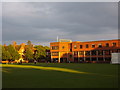
Ipswich School library
View towards the school library block in mid Summer.
Image: © Ben Eagle
Taken: 11 Jun 2008
0.07 miles
7
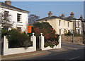
Houses on Anglesea Road
On either side of the junction with Warrington Road in a pleasant residential area of Ipswich.
Image: © Andrew Hill
Taken: 3 Apr 2009
0.08 miles
8
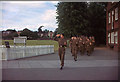
Annual CCF parade, Ipswich School, early 1960s
Each year, the school's CCF contingent were inspected by a serving military officer. The troop is parading down the driveway between the School Field (seen in background left) and the school buildings. The white palisade fencing enclosed the school's weather station. This photo dates from about 1961-63.
Image: © Mike Dodman
Taken: Unknown
0.10 miles
9
The top end of Berners Street
Looking across a gridline, I think most of the properties themselves will be in TM1645.
Image: © Andrew Hill
Taken: 3 Apr 2009
0.11 miles
10
Geneva Road, Ipswich
The everso slightly ornate domestic architecture appears to my untutored eye to indicate 1930s construction.
Image: © Richard Vince
Taken: 18 May 2014
0.11 miles