IMAGES TAKEN NEAR TO
St. Edmunds Road, IPSWICH, IP1 3QT
Introduction
This page details the photographs taken nearby to St. Edmunds Road, IP1 3QT by members of the Geograph project.
The Geograph project started in 2005 with the aim of publishing, organising and preserving representative images for every square kilometre of Great Britain, Ireland and the Isle of Man.

There are currently over 7.5m images from over14,400 individuals and you can help contribute to the project by visiting https://www.geograph.org.uk
Image Map
Images are licensed for reuse under creativecommons.org/licenses/by-sa/2.0
Notes
- Clicking on the map will re-center to the selected point.
- The higher the marker number, the further away the image location is from the centre of the postcode.
Image Listing (61 Images Found)
Images are licensed for reuse under creativecommons.org/licenses/by-sa/2.0
Image
Details
Distance
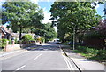
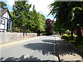
2
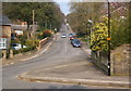
Looking up Constitution Hill
The viewpoint is at the end of Paget Road.
Image: © Andrew Hill
Taken: 3 Apr 2009
0.04 miles
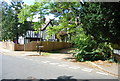
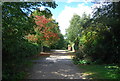
3
Row of houses on Constitution Hill
Looking across the end of Brackenbury Close.
Image: © Andrew Hill
Taken: 3 Apr 2009
0.04 miles
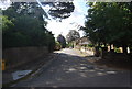
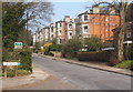
5
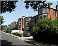
Constitution Hill
These fine houses appear to date from the 1890s, judging by old maps
Image: © Keith Edkins
Taken: 7 Aug 2018
0.05 miles