IMAGES TAKEN NEAR TO
St. Matthews Street, IPSWICH, IP1 3EL
Introduction
This page details the photographs taken nearby to St. Matthews Street, IP1 3EL by members of the Geograph project.
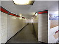
The Geograph project started in 2005 with the aim of publishing, organising and preserving representative images for every square kilometre of Great Britain, Ireland and the Isle of Man.

There are currently over 7.5m images from over14,400 individuals and you can help contribute to the project by visiting https://www.geograph.org.uk
Image Map
Images are licensed for reuse under creativecommons.org/licenses/by-sa/2.0
Notes
- Clicking on the map will re-center to the selected point.
- The higher the marker number, the further away the image location is from the centre of the postcode.
Image Listing (283 Images Found)
Images are licensed for reuse under creativecommons.org/licenses/by-sa/2.0
Image
Details
Distance
1
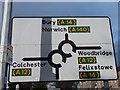
Sign on Norwich Road
The double mini roundabouts in Ipswich. See http://www.ipswichstar.co.uk/news/ipswich_bid_to_scrap_roundabouts_in_norwich_road_have_been_delayed_1_2286190 for more info.
Image: © Hamish Griffin
Taken: 18 Feb 2014
0.01 miles
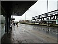
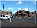
3
Civic Drive at Barrack Corner
The start of Civic Drive (A1022).
Image: © Hamish Griffin
Taken: 21 Mar 2014
0.03 miles
4
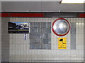
Signs under Barrack Corner
Coming from the town centre direction. Civic Drive is left, Berner's Street is right, St Matthew's Street is straight over (often thought to be Norwich Road) and St Matthew's Street is also behind.
Image: © Hamish Griffin
Taken: 5 Mar 2014
0.03 miles
5
The end of Westgate Street
Coming onto St. Matthew's Street/Crown Street. It is St. Matthew's Street left and Crown Street right but is the same road, the A1156.
Image: © Hamish Griffin
Taken: 21 Mar 2014
0.03 miles
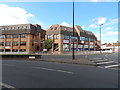
6
Barrack Corner looking towards Berner's Street
At the exit for the town centre.
Image: © Hamish Griffin
Taken: 5 Mar 2014
0.04 miles
7
Virgin Mary Statue in Lady Lane, Ipswich
The statue and plaque below it is at the site of St Marys Chapel which was closed by order of Henry the VIII in 1588.
Image: © PAUL FARMER
Taken: 22 May 2010
0.04 miles
8
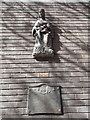
Statue of Lady with a baby on Lady Lane
Maybe it has something to do with http://en.wikipedia.org/wiki/Our_Lady_of_Ipswich.
Image: © Hamish Griffin
Taken: 21 Mar 2014
0.04 miles
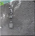
9
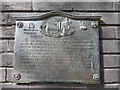
Plaque below Lady statue
The plaque below http://www.geograph.org.uk/photo/3971007.
Image: © Hamish Griffin
Taken: 21 Mar 2014
0.04 miles
10
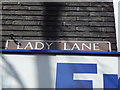
Lady Lane sign
See http://www.geograph.org.uk/photo/3970876 for the lane.
Image: © Hamish Griffin
Taken: 21 Mar 2014
0.04 miles