IMAGES TAKEN NEAR TO
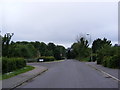
Bigod Close, WOODBRIDGE, IP13 9SQ
Introduction
This page details the photographs taken nearby to Bigod Close, IP13 9SQ by members of the Geograph project.
The Geograph project started in 2005 with the aim of publishing, organising and preserving representative images for every square kilometre of Great Britain, Ireland and the Isle of Man.

There are currently over 7.5m images from over14,400 individuals and you can help contribute to the project by visiting https://www.geograph.org.uk
Image Map
Images are licensed for reuse under creativecommons.org/licenses/by-sa/2.0
Notes
- Clicking on the map will re-center to the selected point.
- The higher the marker number, the further away the image location is from the centre of the postcode.
Image Listing (278 Images Found)
Images are licensed for reuse under creativecommons.org/licenses/by-sa/2.0
Image
Details
Distance
1
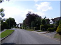
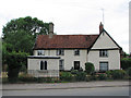
Brook Lane,Framlingham
At the junction with Love Lane
Image: © Geographer
Taken: 20 Jun 2011
0.04 miles
2
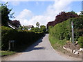
Love Lane footpath to Vyces Road
At the junction with Brook Lane
Framlingham footpath no.92
Image: © Geographer
Taken: 20 Jun 2011
0.04 miles
3
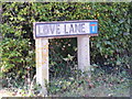
Love Lane sign
At the junction with Brook Lane
Image: © Geographer
Taken: 20 Jun 2011
0.04 miles
6
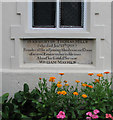
Framlingham: Tomb House - 2
Thomas Mills was a wealthy Baptist timber merchant and philanthropist who endowed a school and the nearby almshouses, and funded the building of the Unitarian Meeting House. As a dissenter, he was refused burial in St Michael's churchyard, so rests instead in a mausoleum in his garden.
Image: © John Sutton
Taken: 14 Jul 2010
0.09 miles
7
Framlingham: Tomb House - 1
Thomas Mills was a wealthy Baptist timber merchant and philanthropist who endowed a school and the nearby almshouses, and funded the building of the Unitarian Meeting House. As a dissenter, he was refused burial in St Michael's churchyard, so rests instead in a little lead-roofed mausoleum in his garden.
Image: © John Sutton
Taken: 14 Jul 2010
0.09 miles
8
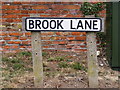
Brook Lane sign
At the junction with the B1116 Station Road
Image: © Geographer
Taken: 17 Jun 2011
0.10 miles
9
Brook Lane, Framlingham
At the junction with Castle Brooks
Image: © Geographer
Taken: 11 Jun 2010
0.10 miles
10
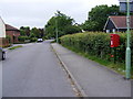
Brook Lane & Brook Lane Postbox
On Brook Lane near the junction with De Vere Close
Postbox No.IP13 8347
Image: © Geographer
Taken: 11 Jun 2010
0.11 miles